
1730 Pierre Moullart-Sanson / Gilles Robert de Vaugondy Map of the World

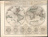
Mappe-Monde ou Description du Globe Terrrestre vû en Concave ou en creux en Deux Hemispheres ou l'on trouve en General le Rapport que toutes ses Parties ont avec les Cieux, entr' Elles, et avec l'Histoire...
Sanson Family Map of the World, Updated. Rare Edition.
- Digital Map Information
- Suitable for large format printing
- Full resolution TIFF file
- ICC color profile embedded
- Delivered instantly via download link
Sanson Family Map of the World, Updated. Rare Edition.
This is Pierre Moullart-Sanson's map of the world, in its c. 1730 edition published by Gilles Robert de Vaugondy. Moullard-Sanson's 17th-century geography and elegant engraving are largely unchanged, with the notable correction to California noted below.A Closer Look
The map's geography is largely consistent with that of Moullart-Sanson's grandfather, Nicolas Sanson, but there are several broad changes. In Africa, the Ptolemaic form of the River Nile (with its source in two massive sub-equatorial lakes) is abandoned, with the source of the Blue Nile noted at Lake Tana. In the North Pacific, the large 'Terre de Iesso' depicted on Sanson's map has here been reduced to a more compact, insular 'Royaume de Huie de la Copagnie.' Mostly, the elder Sanson's mapping survives: Australia and New Zealand appear as per Abel Tasman; a sketched coast for the as-yet-undiscovered Antarctica is retained. The Arctic portions of the map refer to their frozen seas not at all, but the map appears to discourage hopes for a Northwest Passage, presenting no obvious gaps westward in the Canadian Maritime coasts.Fixing California
Moullart-Sanson, following his uncle and grandfather, had in his original composition presented California as an island, as it had appeared on most European maps going back to 1624. His adherence to this model stood in the face of Eusebio Kino's 1705 correction of the myth and De l'Isle's, albeit tepid, refutation of it. By the time Vaugondy acquired the plate in 1730, this canard was no longer acceptable. He amended this glaringly out-of-date feature and emphasized the change with the French notation 'California is considered to be a peninsula, and is attached to the mainland.'The map is distinguished with the six ancillary hemispheres arranged at the bottom of the plate. The three hemispheres to the left present the globe illustrating the stereographic projection viewed at right angles to the equator, parallel to it, and obliquely. Those to the right present equatorial, polar, and oblique azimuthal projections.
This map stands in slight contrast to Pedley's observation that 'Sanson's heirs had been content to republish his work without further corrections.' While Moullart-Sanson was not unlike his predecessors in this respect, he did produce new matter from time to time. Although he acquired a great many of the copperplates of the family firm, Sanson's erstwhile partner, Mariette, retained others. Moullart-Sanson, then, had to engrave new maps to fill those gaps, including the present work. Moullart-Sanson engraved this map, probably in 1705; it was amended c. 1730 by Vaugondy when he inherited Moullart-Sanson's plates and stock.
The Geographical Table
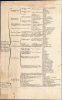
Among Nicolas Sanson's innovations were his popular geographical tables. These logic tables categorized and ranked geographical areas and their subordinate parts in a clear format. By presenting continents, their broader regions, and the subdivision of those regions into kingdoms, principalities, and cities, these tables facilitated memorization of those placenames and their conceptual relationships. They were intended also for use independently of the maps: the title of the separate volume of tables touted them asA Method for Easily Acquiring Knowledge of Geography, and for Identifying the Empires, Monarchies, Kingdoms, States, Republics, and Peoples - both Ancient and Modern - of All Parts of the World; Showing into How Many Specific Regions or Provinces They Are Subdivided, and Which Are Their Most Notable Cities.Sanson's atlases included these tables, and his son Guillaume retained them, as did Moullart-Sanson.
Publication History and Census
This map was engraved for inclusion in Pierre Moullart-Sanson's atlases, probably around 1705. It remained in his atlases thereafter, also appearing in examples of the atlases issued after 1730, when the firm passed to Gilles Robert de Vaugondy. The map is extremely rare on the market, and we have located only one example of this Vaugondy state of the map at the Bibliothèque Nationale de France. Two further examples with the likely spurious dating of 1800 are listed in OCLC at the Newberry Library and Pennsylvania State University.Cartographers
Pierre Moullart-Sanson (1670 - 1730) was a French cartographer active from the end of the 17th century and through the first quarter of the 18th. He was the third of the Sanson family to become Geographer to the King. He was the grandson of the legendary cartographer Nicolas Sanson (1600 - 1667), by his daughter, and nephew of Nicolas' son Guillaume Sanson (1633 - 1703). He acquired the Sanson firm's plates and archives in 1692, and published further editions of the Sanson atlases as early as 1696. He continued in the trade until his death, passing the business on to Gilles Robert de Vaugondy, setting the stage for another French cartographic dynasty. Further Details...
Robert de Vaugondy (fl. c. 1716 - 1786) was a French publishing firm run by Gilles (1688 - 1766) and Didier (c. 1723 - 1786) Robert de Vaugondy. They were map publishers, engravers, and cartographers active in Paris during the mid-18th century. Gilles was the nephew of Pierre Moulard Sanson, and was thus the inheritor of Nicolas Sanson (1600 - 1667), whose stock supplied much of their initial material and whose legacy supplied much of their initial reputation. Graduating from Sanson's maps, Gilles, and more particularly Didier, began to produce their own substantial corpus. The Vaugondys were well-respected for the detail and accuracy of their maps, for which they capitalized on the resources of 18th-century Paris to compile the most accurate and fantasy-free maps possible. The Vaugondys compiled each map based on their own geographic knowledge, scholarly research, journals of contemporary explorers and missionaries, and direct astronomical observation. Moreover, unlike many cartographers of this period, they took pains to reference their sources. Nevertheless, even in 18th-century Paris, geographical knowledge was limited - especially regarding those unexplored portions of the world, including the poles, the Pacific Northwest of America, and the interiors of Africa, Australia, and South America. This gap in knowledge let to divergent geographical approaches, epitomized by the Buache-Vaugondy debates at the French Academie des Sciences - one of the key pivotal moments in the history of modern cartography. Buache, in his Exposé, argued for a Theoretical Geography, which postulated that a systematic and scientific approach could accurately fill in the map in advance of actual exploration. Vaugondy's scathing critique of the Exposé, presented as the Considerations, argued for empirical restraint in cartography, suggesting that unexplored areas should simply be left blank and that mapping itself should rely on documentable current discovery. While Bucahe, with more political acumen and connections, initially came out ahead in the debates, the subsequent decades saw voyages of discovery by Captains James Cook, Jean Francois de Galaup de La Perouse, and George Vancouver disprove most of his map. Nonetheless, by that time, Vaugondy, advanced in age, did not live long enough to see his approach become ascendant. Didier died more celebrated than solvent, and his maps were acquired by Jean-Baptiste Fortin, who in 1787 sold them to Charles-François Delamarche (1740 - 1817). Delamarche, more businessman than cartographer, prospered from the Vaugondy maps, but defrauded Vaugondy's widow, Marie Louise Rosalie Dangy, of her rightful inheritance and may even have killed her. Further Details...
Source
Moulart-Sanson, Pierre and Vaugondy, Gilles Robert de, Cartes et tables de la géographie ancienne et nouvelle., (Paris: Robert) 1730 - 1740.
Condition
Very good. Waterstaining at top margin, entering printed area.Few stains above eastern hemisphere. Marginal mends at top with no impact to printed image; bottom centerfold reinforced. Original outline color. Table page separate but present.
References
OCLC 494504735. Text sheet: see Rumsey 9741.005.