
1700 Pieter van der Aa / Cassini Map of the World

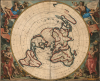

Planisphere terrestre: suivant les nouvelles observations des astronomes.../ Planispherium terrestre: secundum recentiores astronomorum observationes...
Baroque Masterpiece in the Scientific Mapping of The World.
- Digital Map Information
- Suitable for large format printing
- File Size: 34.28 MB
- File Type: ZIP / TIFF
- ICC color profile embedded
- Delivered instantly via download link
Baroque Masterpiece in the Scientific Mapping of The World.
This beautiful north polar projection map of the world, published in 1713 by Pieter van der Aa, is the most attractive depiction of a lost cartographic monument: Giovanni Domenico Cassini's eight-meter world map, which at one time adorned the floor of the Paris Observatory. That mammoth work can be considered the earliest scientific map of the world: it was the first to fix longitude based upon accurate astronomical observation. The present map is a glorious work of baroque art, embellished by the masterful decorative engravings of Gilliam van der Gouwen, based on the drawings of Jan Goeree.A Closer Look
The map is executed on a north polar projection - a method made practical by the paucity of discovered land south of the Tropic of Capricorn at the time it was published. Abel Tasman's discoveries of the west coasts of Australia, Tasmania, and New Zealand appear, but beyond America's Tierra del Fuego and Africa's Cape of Good Hope, no discovered lands existed to be distorted to infinity by the novel projection. The imagined southern continent Terra Australis Incognita has been dispensed with here. The chimera of California as an island appears (although the map is not cataloged in McLaughlin). Greenland is shown as possibly contiguous with the Pacific landmass of Iesso but separate from North America, preserving a potential Northwest Passage.The four corners of the map are filled with superbly executed allegorical engravings illustrating the four seasons, each represented by a titan-like figure surrounded by putti displaying the emblems of the Zodiac appropriate to each given season. Two more putti at each side of the map display banners, one in Latin and the other in French, explaining that the forty-three asterisks found on the map mark the locations from which longitude measurements had been made based on the eclipses of the Jovian moons.
Cassini's Cartographic Masterpiece
The map is based on the mammoth planisphere of Giovanni Domenico Cassini: then the director of Louis XIV's Paris Observatory, Cassini had organized a broad effort to measure longitude, making use of Galileo's method of observing the eclipses of Jupiter's moons. Having trained missionaries and astronomers in the method, Cassini was able to gather observations 'from over forty stations as far apart as Quebec, Santiago, the Cape of Good Hope (assisted by Edmond Halley), Goa and Peking' (Shirley). He then recorded the collected data in a master-map at the Observatory, resulting in a world map whose longitudinal measurements were supported by astronomical observations for the first time, marking the locations of the observations on the map. The present map preserves many of these by means of an asterisk next to the relevant placename. It is not the first re-creation of Cassini's map - his son Jacques produced one with Jean Baptiste Nolin in 1696. But the present work - executed in and around 1712 by publisher François Halma, and republished in 1713 by Pieter van der Aa - is far and away the more artistically accomplished work.Publication History and Census
The map was first engraved by François Halma, with the decorative work drawn by Jan Goeree and engraved by Gilliam van der Gouwen. Shirley dates it approximately 1712, but it could be earlier, though no earlier than 1696. It was among Halma's plates acquired by Leiden map publisher Pieter van der Aa, who replaced Halma's imprints with his own and included the maps in his 1713 Le Nouveau Théâtre du Monde. The Halma printing of this map is unacquirably rare; we are aware of no examples of that edition to have reached the market. The present van der Aa printing of the map is cataloged in perhaps a dozen institutional collections, and it appears on the market from time to time.Cartographers
Pieter van der Aa (1659 - 1733) was a Dutch publisher of maps and atlases active in the late 17th and early 18th centuries. Van der Aa was born in Leyden in 1659. At nine he was apprenticed to a local bookseller and, by 21, had established his own publishing, printing, and auctioneering house. In 1692 Van der Aa was appointed to be one of the High Commissioners of the Booksellers Guild. During his long and impressive career Van der Aa produced thousands of maps, including a vast 28 volume atlas containing no less than 3,000 maps. Few of Van der Aa's maps were original productions, most being copied from the work of earlier cartographers. Nonetheless, when one of Van der Aa's rare original pieces does appear, his style, with unusual projections, elegant engraving, and precise detail, is instantly recognizable and highly desirable. He also pioneered the cartographic idea of separating border artwork from the map plate itself such that every map in a collection could have a similar elaborate border without actually having to re-engrave the complex plates. This technique was used to great effect by later 18th century publishers like Brion de la Tour. Following Van der Aa's death in 1733, his much admired Nouvel Atlas was reissued by the Dutch firm of Covens & Mortier. Today Van der Aa's work is admired for its fine delicate engraving and unusual projections and is considered highly desirable among collectors. Further Details...
Jan Goeree (1670 - 1731) was a Dutch painter, draughtsman and printmaker. He was also known as a poet. He was the son of one Willem Goeree and no details come down to us of his youth in Middleburg. In Amsterdam he was a pupil of Dutch Golden Age painter and art theorist Gerard de Lairesse. He lived out his life in Amsterdam, the city in which most of his work was produced. His engraving appeared in De Fer's Atlas Royal. Tooley's Dictionary is probably mistaken in saying he worked for Pieter van der Aa. Although his imprint is to be found on van der Aa's large format maps, these were executed on behalf of François Halma as early as 1694, and the plates later acquired and reprinted by van der Aa in 1713. Further Details...
François Halma (1653 - 1722) was a Dutch publisher active in Utrecht (starting 1674) and later in Amsterdam where he worked as printer and publisher from 1699-1710. He eventually settled at Leeuwarden, where he died. His output was composed of botanical, theological and historical works, but also, he published a small number of geographies and atlases. In 1695, he published an edition of Gerard Mercator's Ptolemy. His re-issue of Schotanus à Sterringa’s Friesche Atlas in 1698 was regarded among his finest work. He also published an edition of Sanson’s Description de l’Univers. He produced an edition of Falda's plan of Rome in or around 1700. He also caused to be engraved a set of large-format maps of the continents and the world (this latter after Cassini) which are quite rare and appear to have been separately issued. We are aware of institutional copies of the continents having been bound into a 1710 Visscher atlas. The execution of these large and rare maps, drawn by Jan Goeree and engraved by Jan Baptiste, was of a very high quality. The plates were later acquired and reprinted, virtually unchanged, by Pieter van der Aa in 1713. Further Details...
Giovanni Domenico (Jean-Dominique) Cassini (June 8, 1625 - September 14, 1712) was a Savoyard-French astronomer, mathematician, engineer and astronomer. He discovered four of Saturn's moons and observed the division of that planet's rings; he organized a global observation of the eclipses of Jupiter's moons in order to produce the most accurate measure of longitude to date. The data thus gathered he compiled on the famous, eight-meter world map laid out on the floor of the Paris Observatory. He started his family on the path to producing the first topographic map of France using scientific survey, employing the same method of determining longitude. He also produced the first scientific map of the Moon. He was born in Perinaldo, then part of Savoy. Beginning in 1648 he worked and studied at the Panzano observatory near Bologna, establishing there his credentials as an astronomer. By 1650, he would be the chair of astronomy of the University of Bologna. He worked there until he was successfully poached by Louis XIV to help set up the Paris Observatory in 1669. He would be director of that institution until his death in 1712, serving also as astronomer and astrologer to Louis XIV. He would be succeeded by his younger son, Jacques Cassini (February 18, 1677 - April 16, 1756). Further Details...
Condition
Very good. Margins close as usual, with some areas of loss to border reinstated in manuscript.
References
OCLC 80618322.