This item has been sold, but you can get on the Waitlist to be notified if another example becomes available, or purchase a digital scan.
1873 Admiralty Chart or Map of the Southwest Coast of Zanzibar
Zanzibar-owen-1873$325.00

Title
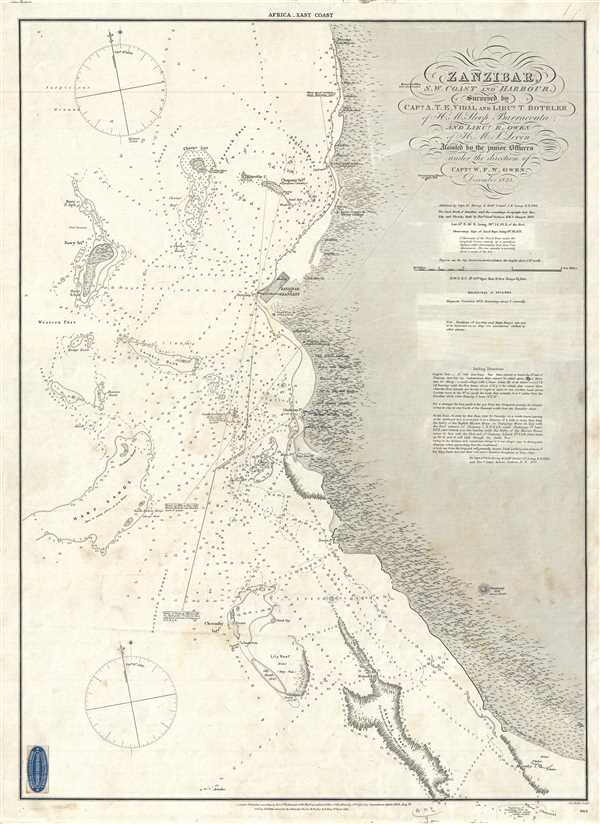
Zanzibar, S.W. Coast and Harbour, Surveyed by Capt. A.T.E. Vidal and Lieut. T. Boteler of H. M. Sloop Barracouta and Lieut. R. Owen of H. M. S. Leven. Assisted by the junior officers under the direction of Capt. W. F. W. Owen.
1873 (dated) 24.5 x 17.5 in (62.23 x 44.45 cm) 1 : 43000
1873 (dated) 24.5 x 17.5 in (62.23 x 44.45 cm) 1 : 43000
Description
This is an 1873 William Fitzwilliam Owen map or chart of the west coast of Zanzibar, Tanzania. The map depicts a portion of the coast of Zanzibar and the Zanzibar Strait including Zanzibar City (Stone Town, Zanzibar or Shangany). The hydrography for this map was produced during Admiral Owen's expedition to map the entire east coast of Africa. Myriad depth soundings populate the Strait, along with newly charted islands, reefs, rocks, and banks. Several landmarks are labeled along the coast of Zanzibar, to aid in navigation. Trees are depicted along the coast, and notations are included to give details to mariners. One section of the map includes a notation which states that the land in that section is between 80 and 100 feet high and slopes steeply down to the beach. Other notations include navigational aids and tips.
The English mission and the minaret in Zanzibar City are labeled. Zanzibar City comprises two main parts, Stone Town and Ng'ambo. Stone Town is the historical core of the city, the former capital of the Zanzibar Sultanate. It was declared a UNESCO World Heritage Site in 2000. Zanzibar was very wealthy and a valuable property under the Sultanate of Oman as it was the main slave market for the Swahili Coast during the 1830s. This was only reinforced after the Sultan moved his capital from Muscat, Oman to Stone Town.
This map was published by the British Admiralty and appears to have been sold by a merchant in Marseille, France, whose advertising pastedown appears in the border.
CartographerS
William Fitzwilliam Owen (September 17, 1774 - November 3, 1857) was an officer in the British navy and a renowned explorer. He embarked on the HMS Culloden as a midshipman at the age of 13 and began his life in the navy. He served under Lord Nelson during the first years of the Napoleonic Wars. In 1803, when war with France resumed, he was given command of the 16-gun brig HMS Safflower and sent to the East Indies, where he would spend the next few years. He explored the Maldives in 1806 and discovered the Seaflower Channel, which is between the islands of Siberut and Sipora off the west coast of Sumatra, that same year. In 1808 he was captured by the French and imprisoned in Mauritius for two years. he returned to England in 1813 and spent from 1815 to 1816 surveying the Canadian Great Lakes.
Between 1821 and 1826, Owen mapped the entire east coast of Africa from the Cape of Good Hope to the Horn of Africa in the sloop Leven. He returned in 1826 with 300 new charts which covered 30,000 miles of coastline, but over half of the original crew had died of tropical diseases. In the mid-1830s, nearing the end of his career, Owen moved his family to New Brunswick, where he became involved in local politics and even served as a justice of the peace. In the final action of his career in the Navy, Owen conducted the definitive survey of the Bay of Fundy between September 1842 and December 1847. Some charts in use today are based on his work. More by this mapmaker...
Vice Admiral Alexander Thomas Emeric Vidal (1792- 5 February 1863) was an officer of the Royal Navy and an accomplished surveyor. Vidal, the youngest of four children, followed his father into the Navy. He began his naval career in December 1803, at the age of 11, as a 1st class volunteer. He served until 1805 when he joined the Royal Naval College at Portsmouth. He was assigned to the HMS Lavinia and spent three years aboard as a midshipman. He received his first commission in 1815 and was appointed to HMS Leven in 1818 as a first lieutenant under William Fitzwilliam Owen. Vidal accompanied Owen on his voyage to Africa to map the eastern coast. Vidal received his first command in May 1823, while one the expedition with Owen, that of HMS Barracuda.
Vidal spent most of his career as a surveyor, who was charged with several tasks, including locating Aitken’s Rock, a rock supposedly in the North Atlantic. There were at least seven different reports of the potential hazard, stating that it was small and protruded only about four feet from the surface of the ocean. In 1830, Vidal was dispatched to find the rock and accurately chart its location. After six weeks of charting supposed locations, Vidal was unable to locate it. However, during the hunt for Aitken’s Rock, Vidal successfully discovered and charted Vidal bank, and the following year was the first to accurately chart and describe Rockall, a nearly 60 foot high islet in the North Atlantic. The United Kingdom claimed the islet in his name in 1955. Learn More...
The British Admiralty Office (1795 - Present) or the United Kingdom Hydrographic Office refers to the Branch of the English government that is responsible for the command of the British Navy. In 1795 King George III created the United Kingdom Hydrographic Office, known in short as the U.K.H.O., to provide top notch nautical charts to the vast Royal Navy. Prior the founding of the Admiralty the surveying and creation of nautical charts was primarily a commercial venture wherein the cartographer himself, more of than not, actually financed the printing of his own material. The great navigator Cook himself is known to have scrambled for funds to publish his own seminal charts - the most important and advanced of the period. The system of privately funded nautical mapping and publishing left vast portions of the world uncharted and many excellent charts unpublished. King George III, responding significant loss in trade revenue related to shipwrecks and delay due to poor charts, recognized the need for an institutionalized government sponsored cartographic agency - the Admiralty. The first head of the Admiralty, a position known as Hydrographer, was the important cartographer Alexander Dalrymple. Dalrymple started by organizing and cataloging obtainable charts before initiating the laborious process of updating them and filling in the blanks. The first official Admiralty Chart appeared in 1800 and detailed Quiberon Bay in Brittany. By 1808 the position of Hydrographer fell to Captain Thomas Hurd. Hurd advocated the sale of Admiralty charts to the general public and, by the time he retired in 1829, had issued and published some 736 charts. Stewardship of the organization then passed to Rear Admiral Sir Francis Beaufort. It was under Beaufort's administration that the Admiralty truly developed as a "chart making" as opposed to a "chart cataloging" institution. Beaufort held his post from 1829 to 1854. In his 25 years at the Admiralty Beaufort created nearly 1500 new charts and sponsored countless surveying and scientific expeditions - including the 1831 to 1836 voyage of the H.M.S. Beagle. By 1855 the Admiralty's chart catalog listed some 1,981 charts. Learn More...
Condition
Very good. Blank on verso.
References
OCLC 929455874.