
Afif, Boulos (sold) (Mahmoud Sayess)

Boulos (Mahmoud Sayess) Afif (1905 - c. 1960) was an Arab photographer, illustrator, and publisher based in Jerusalem in the first half of the 20th century.
AKA: Mahmoud Sayess
Pictorial Jerusalem.
Jerusalem.
sold
- Digital Map Information
- Suitable for large format printing
- Full resolution TIFF file
- ICC color profile embedded
- Delivered instantly via download link
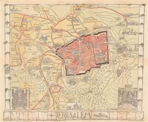
This is a 1935 Bernhard Gauer pictorial map of Jerusalem. The map depicts the city from the Greek Monastery of the Cross to the Chapel of Ascension and the Russian Tower and from the Grand Mufti's House to the German-American Cemetery. The walled Old City serves as the map's focal point with numerous sites illustrated pictorially, including the Dome of the Rock, the Al-Aqsa Mosque, Wailing Wall, the Church of the Holy Sepulcher, the Tower of David, and the Hurva Synagogue. Outside the Old City, many other sites appear, such as the Syrian Orphanage (see below), Hebrew University and Library, the war cemetery, the Church of the Tomb of the Virgin, and the Garden of Gethsemane. Locations important to the visitor, such as hospitals, consulates, the Y.M.C.A., and hotels are also noted. Three vignettes situated along the bottom border illustrate the interior of the Mosque of Omar, Dome of the Rock, Rachel's Tomb, and the interior of the St. Sepulchre. (more details)
Pictorial Jerusalem.
Jerusalem.
sold
- Digital Map Information
- Suitable for large format printing
- File Size: 23.25 MB
- File Type: ZIP / TIFF
- ICC color profile embedded
- Delivered instantly via download link
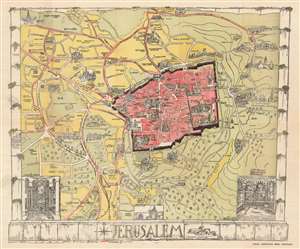
This is a 1935 Bernhard Gauer pictorial map of Jerusalem. The map depicts the city from the Greek Monastery of the Cross to the Chapel of Ascension and the Russian Tower and from the Grand Mufti's House to the German-American Cemetery. The walled Old City serves as the map's focal point with numerous sites illustrated pictorially, including the Dome of the Rock, the Al-Aqsa Mosque, and the Wailing. The Church of the Holy Sepulcher, the Tower of David, and the Hurva Synagogue are also illustrated. Outside the Old City, many other sites, such as the Syrian Orphanage (see below), Hebrew University and Library, the war cemetery, the Church of the Tomb of the Virgin, and the Garden of Gethsemane, are highlighted. Locations important to the visitor, such as hospitals, consulates, the Y.M.C.A., and hotels are also labeled. Three vignettes are situated along the bottom border and illustrate the interior of the Mosque of Omar, Dome of the Rock, Rachel's Tomb, and the interior of the St. Sepulchre. Manuscript notations in ink are present throughout the map and label the Mount of Olives and Gordon's Cavalry. (more details)