
Alvares Seco, Ferdinand (sold)

Ferdinand Alvares Seco (fl. 1560) also Fernando Álvaro Seco, was responsible for drafting the first separate map of Portugal. The first printed versions of his work were dedicated to the Milanese Cardinal Guido Sforza, so it is sometimes thought that he was a member of the Sforzas' court in Milan - it is more likely that he was Portuguese, and the map's dedication to Sforza was tendered by the Cardinal's prospective librarian. Virtually nothing is known with certainty about Alvaro Seco beyond his map, which remained the source map for almost every subsequent map of Kingdom of Portugal for over a century.
Original old color example of the first acquirable map of Portugal.
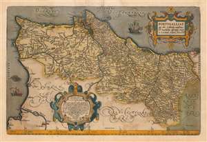
Portugalliae que olim Lusitania, novissima et exactissima descriptio.
sold
- Digital Map Information
- Suitable for large format printing
- DPI: 600
- File Size: 60.34 MB
- File Type: ZIP / TIFF
- ICC color profile embedded
- Delivered instantly via download link
This is an original old color example of Abraham Ortelius' 1570 map of the Kingdom of Portugal, in a Latin edition of 1612. In its first issue it is the earliest acquirable map of that kingdom. The map is oriented to the west, and its composition is balanced and artistic. Ships sail the stippled oceans, and a hirsute monster lurks off the southern coast. The map includes two handsome strapwork cartouches: the title cartouche in the upper right, and at the bottom just left of center, the map's effusive dedication. (more details)