
Ashizawa Keigo (sold) (芦沢馨吾)

Ashizawa Keigo (芦沢馨吾; fl. c. 1930 - 1949) was a Japanese editor and cartographic illustrator most active during World War II. Most of his known work is associated with the publisher Seitosha (正統社; fl. 1930 - 1949).
AKA: 芦沢馨吾
Hawaii as part of the greater Japanese Empire.
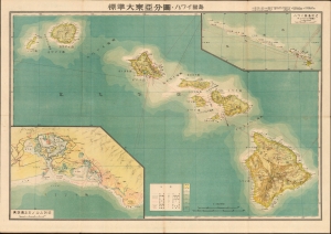
標準大東亞分圖 : ハワイ誻島 / Standard Map of the Great East Co-Prosperity Sphere. Hawaiian Islands.
sold
- Digital Map Information
- Suitable for large format printing
- Full resolution TIFF file
- ICC color profile embedded
- Delivered instantly via download link
This is a 1943 (Showa 18) Seitosha (正統社) map of Hawaii from the Greater East Asian Co-Prosperity Sphere series. The inclusion of the map in the Greater East Asian Co-Prosperity Sphere underscores the extent of Japan's imperial ambitions for the archipelago. It is part of a wider anti-western, anti-western-imperialism propaganda message promoted by Imperial Japan throughout the 1930s and 40s. (more details)
Japanese imperial interest in Luzon.
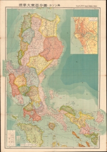
標準大東亞分圖 : ルソン島 / Standard Map of the Great East Asia: Luzon.
sold
- Digital Map Information
- Suitable for large format printing
- Full resolution TIFF file
- ICC color profile embedded
- Delivered instantly via download link
This is the 1943 (Showa 18) Seitosha (正統社) first edition map of Luzon, Philippines, from the Greater East Asia Co-Prosperity Sphere series. The inclusion of the map in the Greater East Asia Co-Prosperity Sphere underscores the extent of Japan's imperial ambitions for the archipelago. It is part of a broader anti-western anti-western-imperialism propaganda message promoted by Imperial Japan throughout the 1930s and 40s. (more details)
Japanese imperialistic Pan-Asianism.
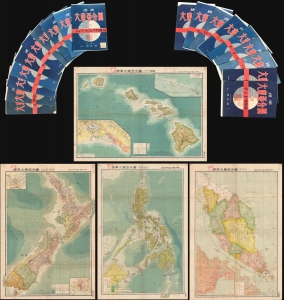
This is an important full set of 20 maps from the 1943 Showa 18 World War II (WWII) Greater East Asian Co-Prosperity Sphere series, by Seitosha (正統社). The maps cover from India to Hawaii and from Japan to Australia, reflecting the Japanese Imperial vision of Pan-Asianism. (more details)