
Baur, Carl Fredrich (sold)

Carl Fredrich Baur (fl. c. 1850 - 1900) was a German map publisher active in Stuttgart during the mid to late 19th century. Baur was little known outside of Germany but nonetheless produced a number of important map most of which had a thematic or historic context. His most notable work is most likely the 1857 Atlas fur Handel und Industrie fur Kaufleute, Fabrikanten und Gewerbetreibende, one of the first industrial and commercial atlases of the 19th century.
Astoundingly complex and monumentally proportioned German map of the world.
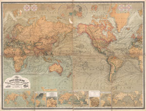
Neueste Karte Der Erde Mit Rucksicht auf das Bedurfniss des Handelstandes sowie fur den Unterricht an Leher-Anstalten.
sold
- Digital Map Information
- Suitable for large format printing
- File Size: 58 MB
- File Type: ZIP / TIFF
- ICC color profile embedded
- Delivered instantly via download link
A vastly complex and enormously proportioned c. 1870 German map of the world by C. F. Baur and Traugott Bromme. Printed in c. 1870 in a multi-toned lithographic process this extraordinary map presents the world on a Mercator Projection. Designed with a ... (more details)