
Bellerby, Russell John (sold)

Russell John Bellerby (July 8, 1902 - July 2, 1985) was an American military officer. Born in Dawson, Yukon Territory, Canada, he graduated from high school in 1920 in Fairbanks, Alaska, and then entered the U.S. Naval Academy, the first appointee to the Naval Academy from central Alaska. In June 1924 he graduated from the Naval Academy and was commissioned as an Ensign. He served in various sea and shore postings throughout the 1920s and 1930s and became the Executive Officer of the U.S.S. Zeilin, an attack transport, in late 1940. He held this position until shortly after November 11, 1942, when the Zeilin was hit by a bomb from a Japanese plane. The Zeilin managed to return to the United States and was repaired. Bellerby was transferred to serve on the staff of various Transport commands and participated in the landings at Attu in the Aleutian Islands, Kwajalein, Peleliu, Guam, and Samar. In early 1945 he was transferred back to the United States and served as Fleet Support Officer of Los Angeles Naval Base for all of 1945. In 1946 he assumed command of the U.S.S. Pitt and participated in the first post-war amphibious training exercises in the Pacific, conducted jointly with the Sixth Army. He became the Commanding Officer of the Tsingtao unit, Joint U.S. Military Advisory Group to the Republic of China in early 1947. He remained in the Navy at least through the Korean War, if not longer, and retired as a Rear Admiral.
Possibly the first ship-to-shore diagram?
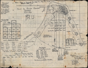
Annex Easy to Commander Task Group Fifty Three Point Eleven Operation Order 3-44. Ship to Shore Diagram D + 1 Day. / Appendix One to Annex Easy to Commander Task Group Fifty Three Point Eleven Operation Order No 3-44. Detailed Diagram of Typical Assault Boat Group.
sold
- Digital Map Information
- Suitable for large format printing
- Full resolution TIFF file
- ICC color profile embedded
- Delivered instantly via download link
An exceptional discovery, this is a 1944 Ship-to-Shore diagram map of the landings on Roi and Namur in Kwajalein Atoll in the Marshall Islands. It is possibly the first printed ship-to-shore diagram issued by the U.S. military - and is certainly the earliest known. Such diagrams were introduced during World War II when amphibious assault doctrine was initially developed. The only other known World War II ship-to-shore diagrams relate to subsequent operations, among them the June 6, 1944, D-Day landings and the invasion of Iwo Jima. (more details)