
André Belloguet (sold)

André Belloguet (1830 - 1873, c. 188x) was a French artist, caricaturist, and lithographer. Belloguet created numerous political cartoons and satirical maps of France and Europe over the course of his career and collaborated with numerous French magazines. Many featured caricatures with incredible expressions, facial structures, and distinctive hats. Belloguet created a large corpus of work during the Franco-Prussian War, the siege of Paris, and the Paris Commune (1870 - 1871) and examples of some of these works can be found in the poster collection of the Département des Hauts-de-Seine in France. A list of forty works published during this era is included in Maurice Quentin-Bauchart's La caricature politique en France pendant la guerre, le siège de Paris et la Commune published in 1890. Most references for Belloguet cite his death date as 1873. However, Roderick Barron's 2008 article Bringing the map to life: European satirical maps 1845 - 1945 states that Belloguet fled Paris after the Paris Commune in 1871 and settled in Brussels, where he worked for the magazine Le Lutin. Also according to Barron Belloguet published at least one satirical map in Brussels that used animals as personifications for European nations entitled L'Europe Animale, Physiologie Comique in 1882.
The Franco-Prussian War and the Paris Commune.
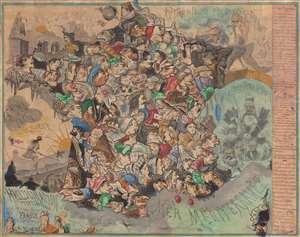
Hallucination topographique sur la carte de France.
sold
- Digital Map Information
- Suitable for large format printing
- File Size: 77.6 MB
- File Type: ZIP / TIFF
- ICC color profile embedded
- Delivered instantly via download link
Published in July 1871, this is satirist André Belloguet's extremely rare caricature map of France. The map emerged at one of the most fraught periods in French history - following closely on the French defeat in the Franco-Prussian War (1870 - 1871), the consequent loss of Alsace and Lorraine, and the chaos of the Paris Commune (1871). (more details)