
Bemis, Waldo Edmund (sold)

Waldo Edmund Bemis (July 26, 1891 - September 9, 1951) was an American artist, illustrator, and designer. Born in Covina, California, Bemis studied art at the Los Angeles School of Art and Design and the University of California, Berkeley. He was a veteran of World War I and spent most of his life in California. Bemis moved to New York in 1928 and spent twenty-two years in the city and made a name for himself as an artist. He returned to California in 1950. He married his wife Margaret in 1917 with whom he had two sons.
An angler's guide to America.
The Game Fish Cyclopedia.
sold
- Digital Map Information
- Suitable for large format printing
- File Size: 96.75 MB
- File Type: ZIP / TIFF
- ICC color profile embedded
- Delivered instantly via download link
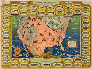
This is a 1947 Waldo Bemis pictorial fishing or angling map of the United States. Depicting the entire continental United States, Bemis uses shading to indicate the distribution of warm-water fish, cold-water fish, and areas where one could potentially find either warm- or cold-water fish. Red circles and stars with white numbers appear throughout, although the vast majority are along the coastlines. These indicate locations where record fish were caught of each of the fifty-three species of fish illustrated in the border. All these notations are explained in a key situated in the lower right quadrant. Vignettes of fishermen are included across the United States, all of whom are experiencing a different degree of success. Vignettes of fishing animals, such as otters, brown bears, seals, and wading birds, also add to this map's appeal. (more details)
Fisherman's guide to America.
The Game Fish Cyclopedia.
sold
- Digital Map Information
- Suitable for large format printing
- File Size: 290.39 MB
- File Type: ZIP / TIFF
- ICC color profile embedded
- Delivered instantly via download link
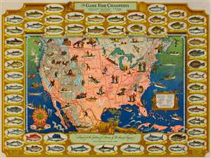
This is a 1947 Waldo Bemis pictorial fishing or angling map of the United States. Depicting the entire continental United States, Bemis uses shading to indicate the distribution of warm-water fish, cold-water fish, and areas where one could potentially find either warm- or cold-water fish. Red circles and stars with white numbers appear throughout, although the vast majority are along the coastlines. These indicate locations where record fish were caught of each of the fifty-three fish species illustrated in the border. All these notations are explained in a key situated in the lower right quadrant. Vignettes of fishermen are included across the United States, all of whom are experiencing a different degree of success. Vignettes of fishing animals, such as otters, brown bears, seals, and wading birds, also add to this map's appeal. (more details)