
Johann-Friedrich Betgen (sold)

Johann-Friedrich Betgen (1721? - 1738) was a surveyor and mapmaker, whose name survives in connection with a single work: the Homann Heirs map of Lithuania Minor. If the dates for Betgen are correct, his 1733 contribution to that map was done at the tender age of twelve. It seems likely that his role was circumscribed to the plan of Gusev which appeared on the broader map: a work so professional and detailed that to credit it to a child beggars the imagination. Nothing is known of Betgen's life and training, although his family name suggests a Dutch background.
Resettlement of a Plague Region, Plagued by War and also Plague.
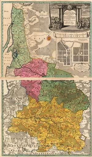
Potentissimo Borussorum Regi Friderico Wilhelmo Majestate Fortitudine Clementia Augustissimo Hancce Lithuaniam Borussicam : in qua loca colonijs Salisburg. ad incolendum Regio nutu concessa chorographice exhibentur D.D.D. Regiae Suae Maiestatis.
sold
- Digital Map Information
- Suitable for large format printing
- Full resolution TIFF file
- ICC color profile embedded
- Delivered instantly via download link
This is a stunning example of the 1735 Homann Heirs map of Lithuania Minor, then the easternmost province of Prussia. The region covered by this grand, two-sheet map is now occupied by Russia's Kaliningrad Oblast (the southern sheet) and the western portion of Lithuania, reaching as far east as modern-day Vištytis and Kudirkos Naumiestis, (Neustadt). The map's detail is rich for the region within the bounds of the Kingdom of Prussia. Across the border into Lithuania, the detail gives way to seemingly endless and trackless forest. (more details)