
Bradlee, Charles Horace (sold)

Charles Horace Bradlee (August 18, 1844 - May 7, 1912) was a Boston based printer and publisher active in the second half of the 19th century. Bradless worked with his brother-in-law George Knowles Snow (1826 - 1885) and elder brother John Emory Bradlee (1831 - c. 1882) as 'G. K. Snow and Bradlee', to publish Snow's Pathfinder Railway Guide for the New England States, from about 1869. Charles died in Tilton, New Hampshire and was buried in Waterdown at the Common St. Cemetery.
One of the earliest commercial relief maps for sale in the US.
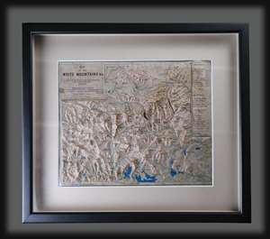
This is a rare 1872 raised relief map of the White Mountains of New Hampshire - considered one of the earliest raised relief maps issued commercially for the American market. The map was issued at the height of the 19th century White Mountains tourism boom that followed railroad penetration into the scenic region. The map is crafted in Papier Mâché to which text has been 'somehow' printed to conform to the terrain. The vertical scale is 1 : 133333. Shading distinguishes elevation, and a key in the upper right notes mountains, exceptional natural sights and lodges (or houses). Red highlights items of interest to the tourist, including the railroad system and various lodges. (more details)