
Brewer, H.G. (sold)

H.G. Brewer (fl. c. 1884 - c. 1905) was a draughtsman employed by the U.S. Hydrographic Office in the late 19th and early 20th centuries.
Presents the state of international communication via submarine cables.
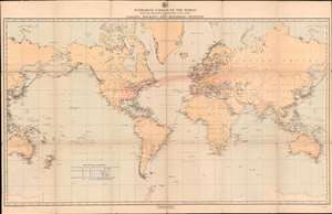
Submarine Cables of the World with the Principal Connecting Land Lines also Coaling, Docking, and Repairing Stations.
sold
- Digital Map Information
- Suitable for large format printing
- File Size: 54.93 MB
- File Type: ZIP / TIFF
- ICC color profile embedded
- Delivered instantly via download link
A striking look at the state of global communication on the eve of the twentieth century, this is an 1896 H.G. Brewer map of the world illustrating the network of submarine cables. The map depicts the world on a Mercator Projection from the Philippines to the Caroline Islands and the Coral Sea and from Greenland to Antarctica. Telegraph cables are highlighted in red. (more details)