
Bridges, William (sold)

William Bridges (1771 - July 10, 1814) was a surveyor and cartographer active in New York City early in the 19th century. Bridges was born in England. He must have arrived in the United States between 1805 and 1806. In 1806 he is advertising his services as a tutor in architectural drawing for young ladies and gentlemen. Bridges was a Federalist and was accused of election fraud when he attempted to force others to vote for his candidates. In cartographic spheres, Bridges is best known for his publication of New York City's grid structure in his important 1811 Commissioner's Plan of New York. The Commissioner's Plan is considered to be 'the single most important document in New York City's development' (Augustyn & Cohen). Unfortunately Bridges had little to do with the actual construction of the Commissioner's plan having stolen credit for the work from the actual surveyor, John Randel Jr. (1787 - 1865). Although Randel is credited for the Commissioner's Plan, it was Bridges who profited on the original issue and successfully held the copyright. In 1807, Bridges also issued an edition of the Mangin-Goerck Plan of New York City, attaching his own name to it as the 'Bridges Plan', and publishing it in a picture guide to New York. He died in 1814, shortly after publishing his version of the Commissioner's Plan, and is buried in St. Paul's Churchyard, Manhattan.
The earliest obtainable example of the influential Goerck-Mangin Plan of New York City - published while it was still relevant.
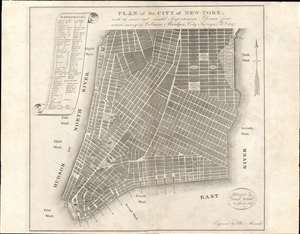
PLAN of the CITY OF NEW-YORK, with the recent and intended Improvements. New York, 1807.
sold
- Digital Map Information
- Suitable for large format printing
- DPI: 600
- File Size: 12.92 MB
- File Type: ZIP / TIFF
- ICC color profile embedded
- Delivered instantly via download link
This is a highly unusual piece with a confused and complex history. The map was published in 1807 by Isaac Riley, William Bridges, and Peter Maverick. It depicts lower Manhattan from roughly Bank Street (current West Village) to the Bowery, but is cartographically unusual as it follows the Mangin-Goerck Plan, a much larger c. 1801 map also engraved by Peter Maverick. That, plan, like the present map, proposed extensive landfill projects and new streets intended to generate clean neat lines and sharp right angles throughout. It is of note that this map pre-dates the 1811 Commissioner's Plan, and thus represents the definitive plan of New York City at the time of publication. This map is thus the only obtainable examples of one of the most important founding cartographic documents relating to the development of New York's street grid, publishing while the Mangin-Goerck map was still relevant. (more details)
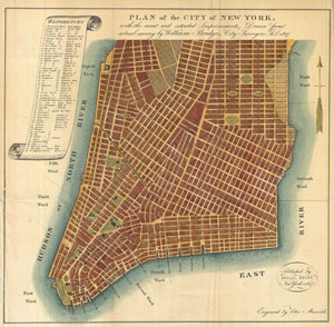
Plan of the City of New York, with the recent and intended Improvements, Drawn from actual survey by William Bridges City Surveyor; AD 1807.
sold
- Digital Map Information
- Suitable for large format printing
- File Size: 6.63 MB
- File Type: ZIP / TIFF
- ICC color profile embedded
- Delivered instantly via download link
An interesting and unusual map, this is William Bridges' 1807 revival or the failed 1801 Mangin-Goerck Plan. Those who know New York's shoreline will pause at the perfect blocks and ridged angles of this plan no more accurate today than it was in 1801 when Mangin ... (more details)