
Brose, Karl Heinrich (sold)

Karl Heinrich Brose (July 16, 1783 - October 18, 1861) was a German cartographic engraver and topographer active in the first half of the 19th century. Brose is considered one of the pioneers of modern topographical engraving. He was born in Berlin and, proving apt at drawing, apprenticed as a geographical engraver under his uncle Karl Jäck, who worked with Sotzmann and Schrötter, among others. He was working on Schrötter's topographical survey of Prussia when Napoleon invaded in 1803. Sometime between that time and 1807, he moved to Paris, where he engraved maps for the Dépôt de la Guerre. From 1813, he served in the military, seeing action in Grossbeeren and Leipzig. After the Napoleonic Wars (1803 - 1815), he returned to map engraving in Germany. Among his more famous works is Heinrich Berghaus's (1797 - 1884) 1826 map of Africa, which, apart from its intrinsic content, remains to this day an unsurpassed sheet of geographical copperplate engraving and laid the foundation for most future topographical engraving. He is likely related to another German engraver, Wilhelm Brose (17xx - 18xx), who engraved fror Perthes, Berghaus, and Flemming, although this has not been confirmed.
'The most beautiful terrain ever engraved' - Hoffmann
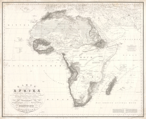
KARTE von AFRIKA Nach den neuesten Entdeckungen und Ansichten, mit besonderer Rücksicht auf Karl Ritters Erdkunde.Ein kritischer Versuch, entworfen und bearbeitet im Jahre 1824 von Heinrich Berghaus.
sold
- Digital Map Information
- Suitable for large format printing
- File Size: 38.76 MB
- File Type: ZIP / TIFF
- ICC color profile embedded
- Delivered instantly via download link
This is Heinrich Berghaus' important 1826 separate-issue map of Africa. As with all of Berghaus' separate issue works, it is scarce today due to small print runs, but was influential in its time for establishing new conventions in the standardized rendering of terrain, one of the major challenges of early 19th-century cartography. It is the great cartographer's earliest known solo work, following only his 1825 contributions to Reymann's topographische Special-Karte von Deutschland. As a whole, this map is the most comprehensive summary of African geography known to Europeans in the early 19th century. (more details)