
Browne, Christopher (sold)

Christopher Browne (fl. c. 1688 – 1712) was a British map seller, book seller, and publisher active in the late 17th and early 18th centuries. Browne apprenticed with Robert Walton whose business he took over in 1688. Little is known of Browne's life but he issued several maps in concert with the Overtons, Herman Moll, and Robert Morden. Brown appears to have retired in 1712, relocating to Chilthorne Domer, a picturesque village in Somerset, England. According to Worms and Baynton-Williams he was still alive as of 1737.
Extremely Rare Imprint of one of Blaeu's Rarest Maps.
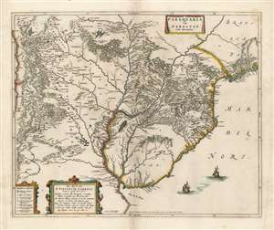
Paraquaria Vulgo Paraguay Cum adjacentibus.
sold
- Digital Map Information
- Suitable for large format printing
- Full resolution TIFF file
- ICC color profile embedded
- Delivered instantly via download link
This rare, superb Blaeu map is one of the finest maps of the lower Rio de la Plata, and the first map to name the Uruguay River. It covers what is now Uruguay, Paraguay, northern Argentina, and part of Chile in magnificent detail, illustrating the complicated regional river system, Argentina's endoheiric lakes, and other bodies of water appear. Some, for example the Lago de los Caracaras flowing into the Corriente River, depict areas accurately that remain poorly mapped today. (The Caracaras would appear to be the Itatí Lagoon.) Mountains and highlands are shown pictorially. Numerous settlements and missions are named. With the assistance of a key in the lower left, one is able to differentiate indigenous settlements from Spanish cities (both extant and ruined,) clerical schools, Jesuit missions (both extant and ruined,) and Franciscan missions. (more details)
Extremely Rare Imprint of a Beautiful Map of the Middle East.
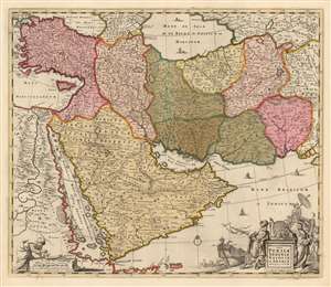
Nova Persiae Armeniae Natoliae et Arabiae Descriptio per F. de Wit.
sold
- Digital Map Information
- Suitable for large format printing
- Full resolution TIFF file
- ICC color profile embedded
- Delivered instantly via download link
This beautifully engraved and colored map is Frederick de Wit's 1666 map of the Middle East, in a rare c. 1690 edition published in London by Christopher Browne. The map spans from Constantinople and the Nile River Valley in the west, to the mouth of the Indus River in the east; it stretches from the Black Sea and the Caspian Sea in the north to the southern tip of the Arabian Peninsula. Tibbets described this map as 'the largest scale map of the area until 1700' and 'the most useful until D’Anville’s map of 1751' which would explain much of its popularity: the map was added to many atlases, with few changes, well into the late eighteenth century. The map is centered on the Persian Empire but includes the whole of the Arabian Peninsula and Asia Minor. The Caspian Sea appears in a distorted, elongated shape which may have been a conflation of both the Caspian and the neighboring Aral Sea. (more details)