
Giovanni Brun (sold)

Giovanni Brun (fl. c. 1748 - 1800) was an Italian engraver active in Rome in the second half of the 18th century. His work mostly consists of view and plans of Rome, geared towards the tourist market. In his later year he also reissued the=North America maps from the French nautical atlas, Neptune Americo-Septentrional.
Rare Italian edition of an important French nautical chart.
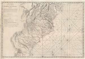
Carte Réduite Des Côtes Orientales Del'Amérique Septentrionale Contenant Partie du Nouveau Jersey, la Pen-sylvanie, le Mary-land, la Virginie, la Caroline Septentrionale, la Caroline Méridionale et la Géorgie.
sold
- Digital Map Information
- Suitable for large format printing
- Full resolution TIFF file
- ICC color profile embedded
- Delivered instantly via download link
A most unusual 1799 Rome imprint of the important 1788 Sartine / Dépôt des Cartes et Plans de la Marine map of the American Mid-Atlantic seaboard. Coverage extends from New Jersey and Pennsylvania southward through Maryland and Virginia, then along the Carolina coast to Georgia and Florida. While this map was originally by the French 'Dépôt General de la Marine' in 1778, the present example bears a 1799 Rome imprint. Although a nautical chart, this map features a magnificent wealth of inland detail as far west as the Appalachian Mountains and the Ohio River. (more details)