
Camocio, Giovanni Francesco (sold)

Giovanni Francesco Camocio (Camozzi)(???? - c. 1575) was a Venetian cartographer, map publisher and printer. He was one of the most prolific of the so-called Lafreri school of Italian mapmakers in the second part of the sixteenth century. Little is known of Camocio's early years. His birthdate and place are not known. He is thought to have lived in Asola (near the Venetian fortress of Crema). In 1552 'Giovanni Francesco Camozzi' and his partners petitioned the Doge of Venice for a 15 year privilege for two books in progress, one a translation of a Greek medical text and the other a translation of Aristotle's Meteorology. The latter was published in 1556 by which time he was operating free of his unnamed partners. He would publish eleven more books until 1571, by which point he is known to have his own copper-plate printing shop. His output includes engravings of drawings and paintings by Titian, and various religious scenes. He is best known as a map printer, being among the Italian map publishers known collectively as the 'Lafreri' school (after Antonio Lafreri, the first of these to include a title sheet in his composite atlases.) The period between 1560 and 1575 resulted in Camocio's publication of no fewer than 36 large maps and many smaller format works. The end point of Camocio's production coincided with the plague which devastated Venice between 1574 and 1577. As there is no record relating to the man after 1575, it is very likely that he succumbed to the pestilence.
Lafreri-school Map of Crete.
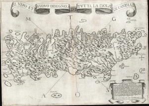
El Vero et Nuovo Disegno di Tutto la Isola di Candia.
sold
- Digital Map Information
- Suitable for large format printing
- DPI: 600
- File Size: 24.36 MB
- File Type: ZIP / TIFF
- ICC color profile embedded
- Delivered instantly via download link
This is a 1564 first-state Lafreri School map of Crete, engraved by Paolo Forlani and published by Giovanni Camocio. This north-oriented map illustrates the island's topography based on the late model exhibited first in the 1513 Waldseemüller map and introduced to Venice via Matteo Pagano's 1538 map. Waldseemüller's model was sufficiently authoritative to make it the prototype for all maps of the island until the 1563 map of the Cretan Calapoda became available. (more details)
A once-in-a-lifetime opportunity.
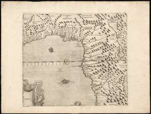
[Gulf of Guinea].
sold
- Digital Map Information
- Suitable for large format printing
- Full resolution TIFF file
- ICC color profile embedded
- Delivered instantly via download link
This is the Gulf of Guinea sheet from Giovanni Francesco Camocio's extraordinary twelve-sheet 1570 wall map of Africa. It is for-all-intent-and-purposes a once-in-a-lifetime opportunity for the serious Africa collector. The complete Camocio map exists in a single known complete example, and even separate sheets, as here, are unobtainable. The map is loosely derived from Giacomo Gastaldi's 1564 map, itself surviving in only 12 examples. Gastaldi's geography was informed by Claudius Ptolemy, the Berber Andalusi diplomat Joannes Leo Africanus (1494 - 1554), the writings of Portuguese scholar João de Barros (1496 - 1570), and the reports of Magellan circumnavigation survivor Duarte Barbosa (c. 1480 - 1521). Gastaldi is also thought to have had access to lost Portuguese portolan charts, influencing the exceptional coastal detail evident here. (more details)
'Lafreri' map of Kefalonia
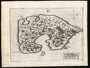
Cefalonia Insula posta sopra il mare Adriatico delli Ill.mi Venetiani piena di arbori et principalm.e di Pini et fichi insula fertilissima ...
sold
- Digital Map Information
- Suitable for large format printing
- DPI: 600
- File Size: 9.08 MB
- File Type: ZIP / TIFF
- ICC color profile embedded
- Delivered instantly via download link
This is a scarce, separately-issued Lafreri-type map of the Greek island of Kefalonia, produced in 1571 by the Venetian Giovanni Francesco Camocio. (more details)
A Separately Issued 'Lafreri' map of Zakynthos
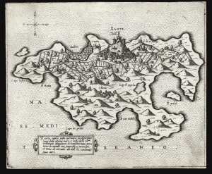
Zante...
sold
- Digital Map Information
- Suitable for large format printing
- DPI: 600
- File Size: 8.99 MB
- File Type: ZIP / TIFF
- ICC color profile embedded
- Delivered instantly via download link
This is a scarce, separately-issued Lafreri-type map of the Greek island of Zakynthos, produced in 1571 by the Venetian Giovanni Francesco Camocio. (more details)