
Cardano y Bauzá, Felipe (sold)

Felipe Cardano y Bauzá (1778 - April 15, 1824) was a Spanish engraver, draughtsman, cartographer, engraver, and naval officer active in Madrid. Felipe was born in Cartagena, the son of Marine musician Antonio Cardano and Antonia Bauzá. He studied at the Real Escuela de Navegación de Cartagena, becoming a navy pilot in 1800. In the same year, he relocated to Madrid and began working with the newly created Dirección Hidrográfico. He also enrolled in the Madrid Real Academia de San Fernando. In 1802, he was sent to Paris to study cartographical engraving under the painter and engraver Sébastien-François Bouclet. In 1803, he was promoted to segundo piloto. In 1808, Napoleon Bonaparte (1769 - 1821) invaded Spain, establishing Joseph-Napoléon Bonaparte (1768 - 1844) as King José I of Spain (1808 - 1813). Cardano refused to cooperate with the regime and was imprisoned in Paris. He escaped in April 1814, returning to Spain, where he resumed his work with the Dirección Hidrográfico. His name appears on numerous nautical charts of the period. His personal passion was landscape engraving, and in 1816 he proposed the establishment of a school to that end in Madrid. In 1819 he was appointed custodian of the Real Museo de Pintura established in El Paseo del Prado. He became ill in 1823, and retired to Málaga, where he died one year later. He was a cousin to the illustrious sailor and swashbuckler Felipe Bauzá y Cañas (1764 - 1834). He is the older brother of José María Cardano y Bauzá (1781 - 18??), considered by many to be the father of Spanish lithographic printing.
First edition of a foundational chart.
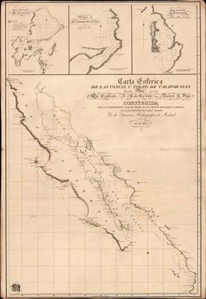
Carta Esferica de las Costas y Golfo de Californias llamado Mar de Cortes Que Comprende desde el Cabo Corrientes hasta el Puerto de S. Diego.
sold
- Digital Map Information
- Suitable for large format printing
- File Size: 26.15 MB
- File Type: ZIP / TIFF
- ICC color profile embedded
- Delivered instantly via download link
A spectacular 1825 1st edition of the Felipe Cardano y Bauzá / Dirección Hidrográfico foundational nautical chart or maritime map of Baja California and the Gulf of California. This important chart is the basis for much of the subsequent mapping of this region and is reflected in subsequent French and English charts. Coverage extends along the west coast of Mexico from San Diego, California, to Cabo Corrientes, Jalisco, Mexico, including all of modern-day Baja, the Gulf of California, and the Sonora and Sinaloa coasts. (more details)