
Civelli, Giuseppe (sold)

Giuseppe Civelli (June 2, 1816 - March 7, 1882) was an Italian publisher, printer, geographer, and engineer active in Milan during the middle part of the 19th century. Civelli was born in Lombardy, Italy, apparently of modest origins. He established a printing house in Milan in 1840. Ten years later, having achieved considerable success with ambitious cartographic publications, he was able to open additional printing houses in Ancona and Turin. When the capital of Italy moved to Florence in 1865, he established a large printing house there to capitalize on government contracts. This process was later replicated in Rome. He died in Florence, but his successors continued to publish under his imprint, Stabilimento Tipografico già C. Civelli well into the 20th century.
One of the largest commercial maps we have seen.
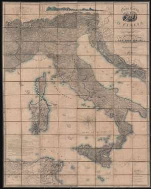
Gran Carta d'Italia.
sold
- Digital Map Information
- Suitable for large format printing
- Full resolution TIFF file
- ICC color profile embedded
- Delivered instantly via download link
A truly 'ginormous' production, this is Giuseppe Civelli's great map of Italy, here in its 1853 edition. The map measures nearly 100 inches high and 80 inches wide, making it one of the largest maps we have seen. This map was issued in the early days of the Italian Risorgimento (1848 - 1871) and can be seen as a unique symbol aspiring to a newly ascendant sense of shared Italian national identity. The map embraces the whole of the Italian peninsula and Sicily, as well as Corsica, Sardinia, Dalmatia, Malta, North Africa, and the northern Italian states. Along the top of the map, there appears a detailed comparative elevation chart. Throughout the detail is staggering, making this great work the finest map of Italy to appear in the 19th century. (more details)