
Cole, Benjamin (sold)

Benjamin Cole (1697 - June 15, 1783) was an English engraver and printer. Cole was known for his engravings of architectural subjects and trade cards, among many other subjects. He was an active Freemason and served as the Official Engraver of the Grand Lodge from 1745 - 1767.
How poorly Europeans understood South America at the beginning of the 18th century!
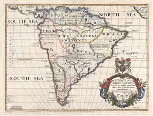
A New Map of South America, Shewing its General Divisions, Chief Cities and Towns; Rivers, Mountains, etc. Dedicated to his Highness William Duke of Gloucester.
sold
- Digital Map Information
- Suitable for large format printing
- DPI: 300
- File Size: 7.04 MB
- File Type: ZIP / TIFF
- ICC color profile embedded
- Delivered instantly via download link
This is a 1700 Edward Wells map of South America. Sparsely illustrated, the scarcity of notations reflects the general lack of knowledge concerning the interior of South America. Annotations in each of the regions provide a date for when Europeans (almost entirely Spaniards, except for the Portuguese in Brazil) conquered different regions and installed their own governments. Two regions, 'The Country of the Amazones' and 'Magelanick Land' are 'little known' to Europeans, meaning that they remained unconquered. Even today, the Amazon Rainforest remains one of the least well-known regions on the planet. The Amazon River cuts its way across the northern portion of the continent. Numerous cities are labeled, including Buenos Aires (Buenos Ayres), Assumption, Cusco, Lima, Quito, and Cartagena. Several cities along the Brazilian coast, such as Pernambuco, San Salvador, Porto Seguro, and Spirito Sancto, are names used in modern Brazil either as city names or as names of region. Two lakes, Lake Parima and the Laguna de Xarayes, are both illustrated here, though only Lake Parima is labeled. Both lakes, which hold equal parts reality and fantasy in their mapping, are central to the European conception of South America and play a critical role in the mapping of the continent. (more details)