
Comissão de Cartografia das Colónias (sold)

Comissão de Cartografia das Colónias (fl. c. 1883 - 1936), in its early years as 'Comissão de Cartographia das Colónias', was an office within the Ministério da Marinha e Ultramar tasked with surveying Portugal's colonies, primarily in Africa. It was dissolved in 1936 and replaced with Junta das Missões Geográficas e de Investigações Colonia.
Portuguese Angola and the Scramble for Africa.
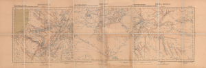
Africa occidental portugueza, Esboço chorographico da provincia d'Angola - Benguela, Moxico, Bihé e Moxico.
sold
- Digital Map Information
- Suitable for large format printing
- Full resolution TIFF file
- ICC color profile embedded
- Delivered instantly via download link
This is a large 1905 3-sheet folding map of central Angola (Portuguese West Africa) made by the Comissão de Cartografia das Colónias. It was published at a time when European powers were fixing borders between their colonies following the 'Scramble for Africa' and Portugal was attempting to exert control over the interior of Angola. (more details)
Portugal attempts to assert control over the Angolan frontier.
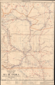
Carta do sul de Angola, compreendendo a região situada ao sul do paralelo 14, Pereira de Eça / [Map of Southern Angola, comprising the region south of the 14th parallel, Pereira de Eça].
sold
- Digital Map Information
- Suitable for large format printing
- File Size: 77.63 MB
- File Type: ZIP / TIFF
- ICC color profile embedded
- Delivered instantly via download link
This is a 1932 map of Pereira de Eça in Huila Province, southern Angola (África Ocidental Portuguesa), produced by the Comissão de Cartografia of the Ministério das Colónias. It depicts the southernmost portion of the Portuguese colony after World War I (1914 - 1918) when Germany was expelled from neighboring South West Africa (Namibia). (more details)