
Covarrubias, Miguel (sold)

Miguel Covarrubias (November 22, 1904 - February 4, 1957) (also known as José Miguel Covarrubias Duclaud) was a Mexican illustrator, caricaturist, painter, ethnologist, and art historian. Born in Mexico City, Covarrubias began producing illustrations and caricatures for materials published by the Mexican Ministries of Education and Communication after graduating from the Escuela Nacional Preparatoria in 1918. At just 19, although he spoke little English, the talented artist grant from the Mexican government to study in New York City. Covarrubias was introduced around New York City art circles by the Mexican poet José Juan Tablada and the New York Times critic Carl Van Vechten. His mastery attained instant recognition and he was soon booked to produce art for many of Manhattan's top magazines. Eventually, Covarrubias become a prominent illustrator and the premier caricaturist for Vanity Fair and The New Yorker. Covarrubias also worked on set designs, and painted murals, one of which was commissioned by the 1939-1940 Golden Gate International Exposition. He married Rosa Rolando in 1930.
Celebrating the indigenous art of the Pacific region.
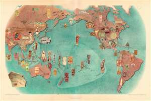
Pageant of the Pacific Plate III: Art Forms of the Pacific Area.
sold
- Digital Map Information
- Suitable for large format printing
- File Size: 170.04 MB
- File Type: ZIP / TIFF
- ICC color profile embedded
- Delivered instantly via download link
This is a 1940 Miguel Covarrubias pictorial map of the Pacific region and its indigenous art forms. (more details)
The diverse plant and animal life of the Pacific region.
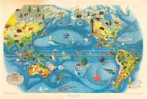
Pageant of the Pacific. Plate II: The Flora and Fauna of the Pacific.
sold
- Digital Map Information
- Suitable for large format printing
- File Size: 156.16 MB
- File Type: ZIP / TIFF
- ICC color profile embedded
- Delivered instantly via download link
This is a 1940 Miguel Covarrubias pictorial map of the Pacific. (more details)
Traditional transportation in the Pacific.
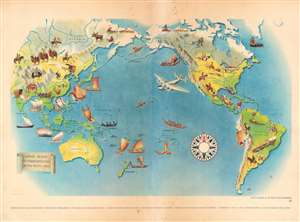
Plate VI. Pageant of the Pacific. Native Means of Transportation in the Pacific Area.
sold
- Digital Map Information
- Suitable for large format printing
- File Size: 21.4 MB
- File Type: ZIP / TIFF
- ICC color profile embedded
- Delivered instantly via download link
This is a 1940 Miguel Covarrubias pictorial map of the Pacific. Pictorial vignettes illustrate indigenous forms of transportation throughout, including elephants in India, camels in Mongolia, llamas in the Andes, horses in the American Great Plains, canoes in the Pacific Northwest, and numerous boats. This print reproduces one of six murals created by Covarrubias for the Pacific House at the Golden Gate International Exposition (1939 - 1940). (more details)
A wonderful pictorial map of the United States published just before America's entry into World War II.
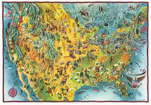
Map of America. / The United States of America.
sold
- Digital Map Information
- Suitable for large format printing
- File Size: 37.25 MB
- File Type: ZIP / TIFF
- ICC color profile embedded
- Delivered instantly via download link
This is a c. 1940 Miguel Covarrubias pictorial map of the United States. Wonderfully illustrated, Covarrubias employs motifs to convey regional differences throughout the country. The Northeast, for example, is filled with skyscrapers and steel mills, and its people are dressed elegantly in business attire, graduation robes, or in the clothes of a workman who operates machinery in a factory. The South is green and filled with fields full of tobacco and cotton, with the exception of Florida, then as now, is home to flamingos, alligators, and women in bathing suits. The Midwest practically glows yellow from the wheat and corn, highlighted by a farmer harvesting. A cowboy riding a bronco appears in eastern Montana, between groups of Native American teepees and a chief in ceremonial regalia. Skiers frolic in the Rocky Mountains beside bears, bighorn sheep, and mines. The Southwest is illustrated as a land of desert, with artists, pueblos, and its own Native American culture. Finally, the Pacific Coast is again lush and green, particularly the Pacific Northwest, where totem poles and salmon and highlighted. This, of course, is not to be outdone by the twin pillars of the redwoods and Hollywood glamour in California. (more details)
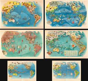
Complete set: Covarrubias' Pageant of the Pacific.
Pageant of the Pacific.
sold
- Digital Map Information
- Suitable for large format printing
- Full resolution TIFF file
- ICC color profile embedded
- Delivered instantly via download link
This is a complete set of the 1943 second edition of Miguel Covarrubias' pictorial maps of the Pacific created as a set of murals for Pacific House at the Golden Gate International Exposition (1939 - 1940). (more details)
Covarrubias!
Florida.
sold
- Digital Map Information
- Suitable for large format printing
- File Size: 43.21 MB
- File Type: ZIP / TIFF
- ICC color profile embedded
- Delivered instantly via download link
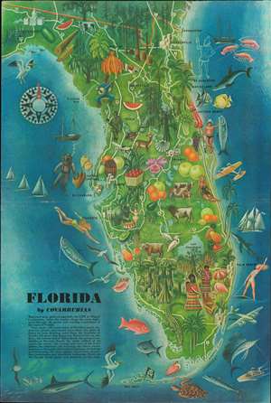
A striking 1946 Miguel Covarrubias pictorial tourist map of Florida that highlights the state's many wonders. Perhaps the text on the map says it best:
This road map, painted especially for LIFE by Miguel Covarrubias, takes the tourist along the main highways through the garish and exciting wonderland of the state of Florida.The whole has been prepared Covarrubias's unique colorful style. (more details)
Close study will reveal many of Florida's sports, industries, history, and tourist attractions: the ghost of Ponce de Leon drinking water from the Fountain of Youth; the pirate flag flying over Pirate's Cove on the Keys; the strange fish of Marineland; the racing automobiles at Daytona Beach; the snake milked of its venom for serum; the swamps and trees of the Everglades; the alligators; the hunting; the circus winter quarters at Sarasota; the Seminole Indians; the fishing and swimming; the cigar, sponge, citrus-fruit, turpentine, watermelon and strawberry industries. There are 105 Florida items, places and products on the map.