
Cowley, William Ambrosia (fl. c. 1683 - 1686) (sold)

First specific map of the Galápagos Islands.
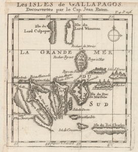
Les Isles de Gallapagos, Decouvertes par le Cap. Jean Eaton.
sold
- Digital Map Information
- Suitable for large format printing
- DPI: 600
- File Size: 4.06 MB
- File Type: ZIP / TIFF
- ICC color profile embedded
- Delivered instantly via download link
This is the first published map of the Galapagos Islands, originally produced by William Ambrosia Cowley and published c. 1710 in Nouveau Voyage Autour du Monde, the French translation of William Dampier's A New Voyage Round the World, a work that influenced Gulliver's Travels, Robinson Crusoe, and Charles Darwin. (more details)