
Dansbury, Cornelius Wesley (sold)

Cornelius Wesley Dansbury (February 15, 1905 - December 16, 1979), often working as C. W. Dansbury or C. Wes. Dansbury (perhaps to distinguish him from his father, of the same name), was a cartographer based in Trenton, New Jersey. Details of his early life are scant, but he may have been a schoolteacher before being drafted into the U.S. Army during the Second World War. During the war, in 1943, he married Charlotte Zweigle and together they had one child. Perhaps due to experience gained in the military, Dansbury began producing maps in the postwar period, focusing mainly on his native Trenton and neighboring parts of New Jersey and eastern Pennsylvania; roughly thirty maps are cataloged in the OCLC under various renderings of his name. Dansbury also compiled a street directory for Trenton in 1951 and was seemingly the co-owner of the Dansbury-Hill Advertising Company, based in Trenton and active c. 1948 - 1952.
Deindustrialization.
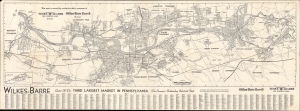
Wilkes-Barre Center of the Third Largest Market In Pennsylvania the Country's Outstanding Industrial State.
sold
This is a 1974 Cornelius W. Dansbury large-format map of Wilkes-Barre, Pennsylvania, and surrounding communities in the Wyoming Valley, printed for the local newspapers the Times Leader and the Wilkes-Barre Record. (more details)