
de Lorenzo, José (sold)

José de Lorenzo (fl. c. 1864 - 1873) was a Spanish geographer and cartographer of the second half of the 19th century. Nothing is known of his life aside from his work with the Dirección General de Hidrografía. Aside from nautical charts, he was a co-author of the important Diccionario marítimo español, which extended to over 5,000 entries as well as a glossary of nautical terms translated between Spanish and French, English, and Italian.
Eyeing the Outer Banks.
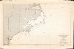
América Septentrional, Costa Este. Hoja IV. Carolina del Norte desde el Cabo Fear hasta el lago de Albemarle.
sold
- Digital Map Information
- Suitable for large format printing
- File Size: 75.2 MB
- File Type: ZIP / TIFF
- ICC color profile embedded
- Delivered instantly via download link
A curious nautical map or chart of the North Carolina coast, produced in 1868 by Spain's Dirección de Hidrografía. Surveyed before the U.S. Civil War but published afterwards, the chart reflects both Spain's investment in naval modernization in the preceding decades and a continued interest in the Americas, despite having lost most of its colonial empire earlier in the century. (more details)