
Depósito de la Guerra (sold)

Depósito de la Guerra (1810 - July 28, 1931) was a department of the Spanish army under the Cuerpo del Estado Mayor founded in 1810 to publish, collect, and preserve military documentation, including letters, maps, photographs, and more. It was reorganized in 1847 as the Reglamento del Depósito, subdividing it into two departments: the Sección de Historia y Estadística Militardel Depósito and the Sección Topográfica y Militar del Depósito. From 1904 it was placed under management of the Estado Mayor del Ejército. The Depósito de la Guerra was abolished by the Decree of July 18, 1831. Their archives were later reassigned to the Servicio Histórico Militar.
Extraordinary Spanish military map of the Philippines.
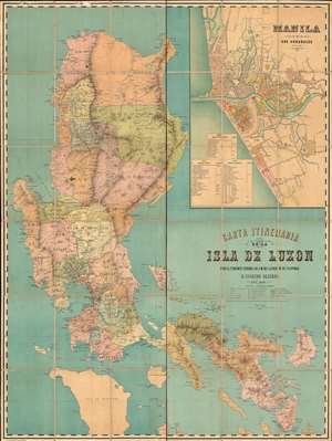
Carta Itineraria de la Isla de Luzon por el Teniente Coronel de E. M. del Ejercity de Filipinas.
sold
- Digital Map Information
- Suitable for large format printing
- Full resolution TIFF file
- ICC color profile embedded
- Delivered instantly via download link
A very rare and important large-scale 6-color chromolithograph 1882 map of Luzon and Manila, the Philippines, by the Spanish military engineer Anselmo Olleros y Mansilla. The map details all of Luzon as well as the surrounding waters. It is color coded by political-military districts (as defined by the Spanish administration) and shows proposed railroads, telegraph stations, existing roads broken down by grade, and more. Topography is illustrated throughout using delicate shading with mountain peaks labeled in red. (more details)