
Derveaux, Daniel-Louis (sold)

Daniel-Louis Derveaux (August 26, 1914 – November 14, 2010) was a French artist active throughout the 20th century. Derveaux was born in Paris, France. By 18 he had already become an excellent artist, mastering drawing, xylography, and copper engraving. His work is varied, but much of his early work, completed in the 1930s, involved French town and country scenes. He fought part in World War II (1939 - 1945), where he produced numerous cartoons and watercolors lampooning the war-time political environment. He began issuing maps with historical themes around 1942. Over the next 30 years he issued more than 50 geographical maps. Stylistically, Derveaux's maps are a composite of the styles developed by Blaeu and Homann, but embracing themes that would have been unusual in early maps – such as the wines and cheeses of France, the Pilgrimage to Santiago de Compostella, the Knights Templar, the Crusades, and more. Derveaux died in his adopted home of Saint-Malo in 2010. Derveaux produced thousands of prints in his lifetime and sold them through his firm, Editions d'Art Daniel Derveaux. Daniel's son, Pierre Derveaux took over Editions d'Art Daniel Derveaux in 1982 and issued several stylistically similar maps on his own account.
Includes inset maps of the Bordeaux and Bourgogne wine regions.
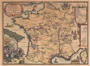
Fromaiges et Vignobles.
sold
- Digital Map Information
- Suitable for large format printing
- File Size: 13.98 MB
- File Type: ZIP / TIFF
- ICC color profile embedded
- Delivered instantly via download link
This is a 1963 Daniel-Louis Derveaux map of France, illustrating French wine and cheese producers. The map depicts the region from the English Channel and Belgium and Luxembourg to the Mediterranean Sea and from the Bay of Biscay to Germany, Switzerland, and Italy. ... (more details)
The Way of St. James... it is not the destination but the journey.
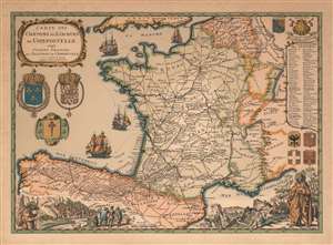
Carte des Chemins de S. Jacques de Compostelle 1648 Camino Francés de Santiago de Compostela.
sold
This is a 1973 Daniel-Louis Derveaux map of France and northern Spain, illustrating the historic pilgrimage to Santiago de Compostela. Derveaux crafted this map in the 17th - 18th century styles of J. B. Homann and Blaeu, but in fact the map was issued as a novelty item in the early 1970s. Dotted lines illustrate the historic pilgrimage routes across Europe from centers in Paris, Vezelay, and Le Puy, across the Pyrenees near Pamplona, then directly west across northern Spain to Santiago, located in the far northwestern province of Galicia. Iconography associated with the pilgrimage, including a scallop shell and multiple armorial crests, surround the map. In the lower right and left, vignette views feature a traditionally garbed pilgrim, complete with staff, hat, and scallop shells. (more details)