
Dien Sr., Charles (sold)

Charles Dien Sr. (17xx - 18xx) was a French engraver and map publisher. Dien worked extensively with Charles-François Delamarche (1740 - 1817). His son, Charles Dien Jr. (February 9, 1800 - 1870), was a prominent globe maker who himself worked closely with C. F. Delamarche's son, Félix Delamarche.
Ephemeral Indiana Company Colony in modern day West Virginia.
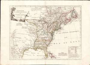
Etats-Unis de L'Amérique Septentrionale Avec Les Isles Royale, de Terre Neuve, de st. Jean, L'Acadie et c.
sold
- Digital Map Information
- Suitable for large format printing
- Full resolution TIFF file
- ICC color profile embedded
- Delivered instantly via download link
An uncommon and important 1785 - 88 Charles Delamarche and Charles Dien map of the fledgling United States shortly after the American Revolutionary War. This map is important as the first to describe the 1784 Jeffersonian Ordinance, in doing so the first to apply the term Michigan to a land area, and for its detailed illustration of the new international borders ratified under the 1783 Treaty of Paris. It is also the first to show the mercantile concession 'Indiana' in the vicinity of modern-day West Virginia. Geographically the map covers from James Bay and Labrador to Florida and the Bahamas, as well as from the Rio de Norte (Rio Grande) to the Atlantic seaboard and Newfoundland. (more details)