
Dowling, Ernest J. (sold)

Ernest J. Dowling (January 18, 1880 - December 6, 1962) was an English businessman, investor, and advertiser Dowling and his family immigrated to South Dakota sometime before 1900. Dowling became Secretary of the Yankton (South Dakota) Chamber of Commerce in January 1930. Dowling married Helen French in 1913 with whom he had one son. Helen died in September 1962.
South Dakota's 'great industrial development'.
South Dakota The Sunshine State.
sold
- Digital Map Information
- Suitable for large format printing
- Full resolution TIFF file
- ICC color profile embedded
- Delivered instantly via download link
This is a 1929 Opie Chambers and Ernest J. Dowling pictorial bird's-eye view map of South Dakota - 'The Sunshine State'. The map promotes South Dakota's potential for 'industrial improvement'. (more details)
A pictorial birds-eye-view of South Dakota promoting the state's impending 'great industrial development'.
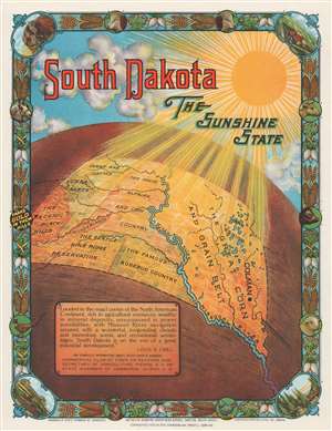
South Dakota The Sunshine State.
sold
- Digital Map Information
- Suitable for large format printing
- File Size: 8 MB
- File Type: ZIP / TIFF
- ICC color profile embedded
- Delivered instantly via download link
This is a 1929 Opie Chambers and Ernest J. Dowling pictorial map of South Dakota - 'The Sunshine State'. Created as promotional material extolling South Dakota's many advantages geared toward 'industrial improvement', the map illustrates South Dakota from above in a pseudo bird's-eye-view style. The entire state is depicted, and it is divided into different industrial regions using shading. Bold capital type extolls the different parts of the state: the 'lake region', 'The Great Corn and Grain Belt', 'The Great Alfalfa and Cow Country', 'The Fertile Pine Ridge Reservation', 'The Wonderlands', and 'The Scenic Black Hills'. 'Sheep and Cattle' and 'Sugar Beets' are noteworthy in northwestern South Dakota. The Missouri River, illustrated in a brilliant blue, crosses the state diagonally. A laudatory quotation is included in the lower left quadrant, proclaiming everything South Dakota has to offer. The whole is surrounded by a pictorial border made up of illustrations of South Dakota agriculture, livestock, and wildlife. Larger vignettes occupy the four corners and highlight Mount Rushmore, a farm scene, Ice Box Canyon, and a sugar factory. (more details)