
Elliott, David H. (sold)

David H. Elliott (c. 1840 - September 30, 1900), a.k.a. 'Colonel', was a leading figure in the agricultural community, a journalist, a railway agent, and an all-around 'booster' active in Florida and the southeastern U.S. in the late 19th century. Details of his biography are scant but he appears to have been born in Alabama and likely served in the U.S. Civil War on the side of the Confederacy, resulting in his commonly used title, Colonel. Elliott founded the agricultural periodical The Florida Dispatch in the 1870s, and afterwards became associated with the Plant System of railroads, often touring with potential land buyers around the state and traveling to other states to promote Florida as a destination for investment and settlers. Perhaps most impressively, he commissioned a colossal map of Florida's phosphate lands for the 1895 Cotton States and International Exposition in Atlanta Georgia. The map consisted of ten sheets, each 4.5 x 10 feet in size, resulting in a map covering 900 square feet of wall space when joined. He served as the General Land Agent of the Plant-affiliated Associated Railway Land Department of Florida for much of the 1890s. He also was for many years the secretary and treasurer of the Florida Press Association, and also served as secretary of the Florida Fruit-Growers Association and Chairman of the Committee of Transportation of the Florida Horticultural Society. After working for the Plant System, Elliott managed the Florida Dispatch Line, a freight railway that primarily handled produce bound for northern markets. At the time of his death, Elliott was working as Land Agent for the Southern Railway in Charleston, South Carolina.
First map of the 'Plant System' in Florida.
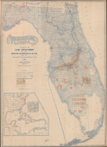
A New Sectional Map of Florida.
sold
- Digital Map Information
- Suitable for large format printing
- Full resolution TIFF file
- ICC color profile embedded
- Delivered instantly via download link
This is a rare 1888 large-format map of Florida prepared by the Land Department of the South Florida Railroad and the Plant Investment Company, and printed by Matthews, Northrup, and Co. It depicts 'Plant System' of railroad and land magnate Henry B. Plant (1819 - 1899) as it was reaching its apex, expanding into South Florida and linking it with wider regional rail and steamship connections. (more details)
Impressive Reach of the Plant System in Florida.
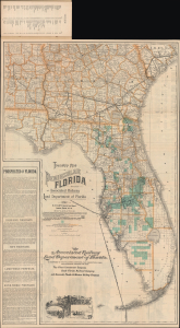
Township Map of Peninsular Florida. / Florida Map Illustrating its Geographical Position and showing Routes of the 'Plant System' of Railway and Steamship Lines / Map Showing the Lands of the Associated Railway Land Department of Florida.
sold
- Digital Map Information
- Suitable for large format printing
- Full resolution TIFF file
- ICC color profile embedded
- Delivered instantly via download link
This is an 1892 promotional map of Florida, prepared by David H. Elliott of the Associated Railway Land Department of Florida, and printed by Matthews, Northrup, and Company. While promoting Florida generally, it specifically highlights the railways, steamship lines, and lands of the Plant System (railroads), a major player in Florida's land and investment boom at the time. (more details)