
Enthoffer, Joseph (sold)

Joseph Enthoffer (1818 - April 6, 1909) was an Austrian-American copper-plate engraver. Enthoffer immigrated to the United States in 1857 to accept a position as an engraver for the United States Coast Survey and worked for the Survey until he retired in 1899. He married his wife Elizabeth in St. Petersburg, Russia in 1855 and they had three children.
A beautifully engraved map of Mount Desert Island - the future site of Acadia National Park.
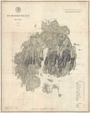
Mount Desert Island Maine.
sold
- Digital Map Information
- Suitable for large format printing
- File Size: 5.2 MB
- File Type: ZIP / TIFF
- ICC color profile embedded
- Delivered instantly via download link
This is an 1875 U.S. Coast Survey map of Mount Desert Island, Maine. An impressively clean and crisp imprint, the map depicts the entire island from Moose Island to Round Porcupine Island and from the Mount Desert Narrows to Baker's Island. Numerous locations throughout the island are labeled, including Bar Harbor, Seal Harbor, Seal Cove, Bass Harbor, Town Hill, and Somesville. Individual buildings are illustrated as black squares throughout the island, though only the lighthouses at Bass Harbor, Baker's Island, and Bear Island are labeled. Roads snake their way around the island, connecting each of the settlements and venturing into the island's interior. A table of heights above mean high water of mountains and other locations on the island is situated in the lower left corner.
(more details)
(more details)