
Ewen, Hamilton (sold)

Hamilton Ewen (1838 - December 15, 1893) was a surveyor and draftsman active in New York City in the late 19th century. He born in Brooklyn and active as a private surveyor in New York City from at least 1863. He was employed by New York City from about 1867 to at least 1892 and is associated with many important New York civic improvement projects, among them street widening, grading work, and new street construction.
One of the earliest maps to show Riverside Park.
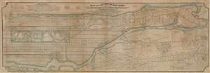
Map of the City of New York, North of 55th Street, Showing on the 'West Side', the Streets, Roads, Avenues and Public Places, established, widened and retained, and the New Pier and Bulk Head Lines and c., as Laid out by the Commsnrs. of Central park. Also showing on the East Side, The Extenson of Madison and Lexington Avenues, The Location fo the Harbor Commissioners, Bulk-Head and Pier Lines, together with the Sizes of the Blocks, Widths of Streets and Avenues, The Elevations of Established Grade, Dimensions and Distances complete.
sold
- Digital Map Information
- Suitable for large format printing
- File Size: 126.62 MB
- File Type: ZIP / TIFF
- ICC color profile embedded
- Delivered instantly via download link
An extremely rare privately published map of New York City's Manhattan above 55th street drawn by Hamilton Ewen and published in 1869 by Hamilton E. Towle. Although a commercial rather than official venture, the map offers impressive size and detail, noting information relating to the enormous project of street grading and leveling then occurring on what is today the Upper West Side. It also notes prospective improvements on the docks, references real estate transactions, proposed rail lines, and notes street widths. Towle clearly recognized the commercial value in such a map to real estate developers and speculators. (more details)