
Forlani, Paolo (sold)

Paolo Forlani (fl. 1560-1571) was an Italian cartographer and engraver of maps and views, working in Venice between 1560 and 1571. His early life is obscure: he is thought to have hailed from Verona. There is not even a date available for his death, although it is probable that he was claimed by the 1574-75 plague that killed 30% of Venice's population, and which seems to have impacted the printing community of that city disproportionately. Even within the narrow period of 1560 to 1571, there are about a hundred maps and prints that can be attributed to him, so it is probable that he was even more prolific. A good census of his work is complicated by the fact that most of his work was printed by other publishers under their imprints: Forlani engraved maps and views for Camocio, Bertelli and Zaltieri. Matters are complicated by the reprinting of plates by two or more publishers, as plates were handed down from one to another.
First detailed, printed map specifically of South America.
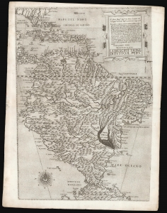
La descrittione di tutto il Peru.
sold
- Digital Map Information
- Suitable for large format printing
- DPI: 600
- File Size: 42.91 MB
- File Type: ZIP / TIFF
- ICC color profile embedded
- Delivered instantly via download link
A superb, untrimmed, first-state example of Paolo Forlani's rare 1562 map of South America. It is the first large-scale, accurate printed map of the southern part of the Americas and is the only map of South America to be produced in the 'Lafreri School' of mapmaking. It is among Forlani's greatest works, and is a prize map not only for collectors of South America in particular, but also the Caribbean, Florida and Bermuda. Through its connection to the 1562 map of Diego Gutiérrez, it offers the most direct available link to contemporaneous Spanish mapping of her American colonies obtainable. (more details)
Lafreri-school Map of Crete.
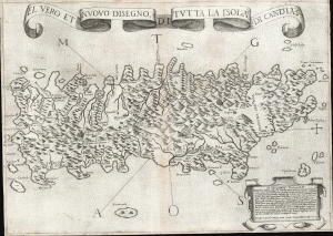
El Vero et Nuovo Disegno di Tutto la Isola di Candia.
sold
- Digital Map Information
- Suitable for large format printing
- DPI: 600
- File Size: 24.36 MB
- File Type: ZIP / TIFF
- ICC color profile embedded
- Delivered instantly via download link
This is a 1564 first-state Lafreri School map of Crete, engraved by Paolo Forlani and published by Giovanni Camocio. This north-oriented map illustrates the island's topography based on the late model exhibited first in the 1513 Waldseemüller map and introduced to Venice via Matteo Pagano's 1538 map. Waldseemüller's model was sufficiently authoritative to make it the prototype for all maps of the island until the 1563 map of the Cretan Calapoda became available. (more details)
Behold! A Rare, Lafreri-school Geneva.
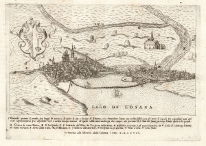
[Geneva].
sold
- Digital Map Information
- Suitable for large format printing
- File Size: 6.91 MB
- File Type: ZIP / TIFF
- ICC color profile embedded
- Delivered instantly via download link
This is a rare 1567 prospect of Geneva, Switzerland, engraved by Paolo Forlani. It presents the city as 'Protestant Rome,' the seat of the Reformation in Europe. The Italian Catholic engraver of the map addresses his audience: Behold how curious the world is today to see the site and form of Geneva! The city's distinctive profile, remoteness, and unfamiliarity to the Catholic reader doubtless inspired wonder. (more details)