
Fornari, Mauro (sold)

Mauro Fornari (fl. 1730 - 1797) was an Italian monk and cartographer. He was a member of the Olivetan order, and appears to have lived and worked in Milan. His only printed cartographic works are a set of six maps of the state of Milan (Como, Cremona, Lodi, Milano, Pavia and Varese) engraved by Domenico Cagnini. The individual maps appear to be quite scarce, only appearing in a few institutional collections. The full set seems only to be held in the Herzogin Anna Amalia Bibliothek Klassik DEHAA. A further work attributed to Fornari, though not apparently published, is recorded in the Convento di S. Marco: a 6-sheet Pianta di Milano.
One-of-a-kind 1700s manuscript map of Lake Como!
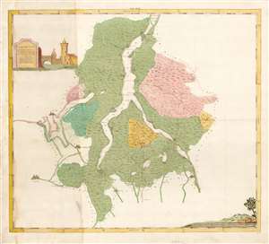
La Provincia Di Como a norma del compartimento della Lombardia Austriaca pubblicatosi l'anno 1786. colla divisione selle su Valli cioe Della Valsasina, Della Valintelvi, Della Valsolda, Della Valassina, Della Valtaleggio.
sold
- Digital Map Information
- Suitable for large format printing
- Full resolution TIFF file
- ICC color profile embedded
- Delivered instantly via download link
This is a beautifully drawn, inked, and colored c. 1790 manuscript map of Lake Como in Lombardy, hailed as the most beautiful lake in the world. This map's author is unknown, but the cartographic detail is derived from the scarce 1790 work of the Olivetan monk Mauro Fornari. The map embraces all of Lake Como, Lake Lugano, and the smaller lakes in their immediate vicinity. It reaches as far north as the Lago di Mezzola (Chiavenna) and as far south as Rovellsca; the western and eastern extents correspond with the upper reaches of the River Tresa, and the commune of Vedeseta, Valtaleggio. As is suggested in the map's extended title, it highlights - employing tasteful hand color- the five Valleys forming Como's primary divisions: Valsasina, Val Intelvi, Val Solda, Valassina, and Val Taleggio. (more details)