
Fournier, Daniel (sold) (Mad Geometer)

Daniel Fournier (Mad Geometer; c. 1711 - 1766) was a French-British engraver, likely of Huguenot descent, based in England. Fournier is an elusive figure. A single engraving of him, a self-portrait, survives in the Royal Collection Trust, where he describes himself as an 'à-la-mode beef-seller, shoemaker, and engraver'. He also, according to the Dictionary of National Biography, sold butter and eggs, modeled in wax, and taught drawing. In 1761, he published A Treatise of the Theory and Practice of Perspective, wherein the Principles of that most Useful Art are Laid Down.... Apparently, when writing this work, he developed the habit of making chalk diagrams on alehouse tables; he thus became known locally as the 'Mad Geometer'. Fournier engraved several maps, including a survey of the Leeward Islands, and the monumental Caskell-Simpson map of Jamaica. He died in Wild Court, Wild Street, London, in 1766.
AKA: Mad Geometer
Slave-suppression Masterplan.
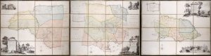
To the Right Honorable Robert Earl of Holdernesse, this map of the County of Cornwall, in the Island of Jamaica. (laid down from the papers, and under the direction of Henry Moore Esqr. His Majesty's Lieutenant Governor, and Commander in Chief of that Island, in the years 1756,-57,-58,-59,-60, and 61, and from a great number of actual surveys performed by the publishers) is humbly inscribed. / To the Right Honorable Wills Earl of Hillsborough, First Lord Commissioner of Trade and Plantations, this map of the County of Middlesex, in the Island of Jamaica. (laid down from the papers, and under the direction of Henry Moore Esqr. His Majesty's Lieutenant Governor and Commander in Chief of that Island in the years 1756,-57,-58,-59,-60, and 61, and from a great number of actual surveys performed by the publishers) is humbly inscribed. / To the Right Honorable George Grenville Esqr. First Lord Commissioner of the Treasury, Chancellor and under Treasurer of the Exchequers and c. and c. This map of the County of Surry, in the Island of Jamaica. (laid down from the papers and under the direction of Henry Moore Esqr. His Majesty's Lieutenant Governor and Commander in Chief of that Island in the years 1756,-57,-58,-59,-60, and 61, and from a great number of actual surveys performed by the publishers)is humbly inscribed.
sold
A seminal production, this is the 1763 Craskell-Simpson map of Jamaica, in three parts. It is the first broadly accurate map of Jamaica and the template for most subsequent representations of the island until the Roberston map of 1804. More importantly, the Craskell-Simpson map is best understood as a response to Tacky's Rebellion (April 1760 - October 1761) and, as such, is a masterplan for slave suppression. The map was commissioned by Henry Moore (1714 - 1769), who also, ironically, commissioned the Ratzer plan of New York, then likewise on the cusp of rebellion. It is the only work (either written or graphic) that records virtually every plantation and pen (large farms) in Jamaica at the height of the island's sugar boom, when it was the most valuable possession of the British Empire. (more details)