
Frolov, Kirill Fedorovich (sold) (Кирилл Федорович Фролов)

Kirill Fedorovich Frolov (Кирилл Федорович Фролов; 1748 - November 18, 1810) was a Russian copper plate engraver serving the Russian Academy of Sciences at St. Petersburg. Frolov studied draftsmanship, painting, and engraving under the well known master engraver Mikhail Ivanovich Makhaev (Михаи́л Ива́нович Маха́ев; 1718 - 172). His two sons Nikolai (1795 - ?) and Semyon, were also engravers.
AKA: Кирилл Федорович Фролов
One of the first specific Russian maps of eastern Siberia.
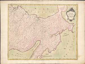
Territorii Jakutensis pars orientalis.
sold
- Digital Map Information
- Suitable for large format printing
- Full resolution TIFF file
- ICC color profile embedded
- Delivered instantly via download link
An exceptional separately issued 1771 Ivan Fomic Treskot map of Siberia, part of the Treskot-Schmidt effort to map Siberia between 1770 and 1776. This map represents one of the earliest specific published maps of northeastern Siberia. Coverage extends from the Kolyma River to the Bearing Strait and from the bulbous Tschtuki Peninsula to Penzhin Bay and Shielikhov Gulf (northern Sea of Okhotsk), and northern Kamchatka. The map is a composite of the finest cartographic knowledge then available to the Russian Academy at St. Petersburg. The treatment of the complex inland river systems in particular represents a major step forward in regional cartography. (more details)