
Gibbs, Jonathan Danforth (sold)

Jonathan Danforth Gibbs (May 24, 1796 - March 2, 1882) was a New Hampshire cobbler, as well as an amateur historian and surveyor active in Jaffrey in the mid-19th century. He was born in Ashburnham, Massachusetts, but settled in Jaffrey in 1821. Achieving some success as a cobbler, he built a two-story home in Jaffrey Center, which still stands as 385 Main Street. His leisure time was dedicated to studying local history and geography. In 1850 he drafted and published a large-scale map of Jaffrey, considered the first separate specific map of that town. Gibbs died in Jaffrey in 1882.
First published map of Jaffrey, New Hampshire.
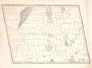
Map of Jaffrey N.H. by J. D. Gibbs, March 1850.
sold
- Digital Map Information
- Suitable for large format printing
- DPI: 600
- File Size: 31.48 MB
- File Type: ZIP / TIFF
- ICC color profile embedded
- Delivered instantly via download link
This is the 1850 Jonathan Danforth Gibbs large-scale map of Jaffrey, New Hampshire, considered the first separately issued map of that region. Mount Monadnock, one of the highest points in southern New Hampshire and at the time the stomping ground of the transcendentalists, appears prominently yet idiosyncratically illustrated in the upper left. (more details)