
Hales, John Groves (sold)

John Groves Hales (1785 – May 20, 1832) was a cartographer, civil engineer, and surveyor active in Massachusetts in the early part of the 19th century. He is considered by some to be one of the most influential and important New England cartographers of the early 19th century. He was born in England around 1785 and there trained as a civil engineer. He was employed on an embankment and diking project in Somerset, England between 1803 and 1806. Around 1810 Hales emigrated to the Portsmouth, New Hampshire where he took on various surveying projects, but private and public. He also began surveying New England cities and towns using advanced and highly accurate European style trigonometric techniques – a sharp contract to the rod and chain system more commonly used in the United States at the time. His first major cartographic work in the United States is an 1812 map of Portsmouth, New Hampshire. Around 1813 he relocated to Boston, Massachusetts. In 1814 he issued a large-scale map of Boston – the most detailed such map to date. Around 1819, he jointly published, with John Melish, the first trigonometric map of the vicinity of Boston. In that same year, he was commissioned by the City of Boston to produce a vast large scale map of Boston, the manuscripts for which survive in the Boston city records. Unfortunately the massive map itself was not published in Hales' lifetime. Hales luck turned sour when, in 1823 he was convicted of forgery and sentenced to 3 years of incarceration. It is unclear if he served time or not, for in 1825 he published a highly detailed map of Essex. He remained a highly active surveyor and mapmaker, with some 45 town planes to his name, until his death in 1832. Hales is buried in the St. Matthews Episcopal Church in South Boston.
The first large scale trigonometric survey of the Boston vicinity since Des Barres.
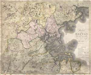
Map of Boston and its vicinity from Actual Survey.
sold
- Digital Map Information
- Suitable for large format printing
- Full resolution TIFF file
- ICC color profile embedded
- Delivered instantly via download link
An exceptional 1819 first edition wall map of Boston, Massachusetts jointly published by John Groves Hales and John Melish. Centered on Boston, Hales' map covers some 720 square miles from Acton to Scituate and from Beverly to Walpole. Hales offers exceptional ... (more details)