
Harris, John (sold)

John Harris (fl. 1686 – 1730) was a British cartographer, engraver and draughtsman active in London during the late 17th and early 18th centuries. Harris is believed to have been born in Northamponshire but little else is certain regarding his personal life as 'John Harris' was an exceedingly common name be 17th century London. Nonetheless, his known work includes engravings for Philip Lea, Robert Morden, Herman Moll, and others.
Vitriolic Presentation of Greece Occupied by the Ottoman Empire.
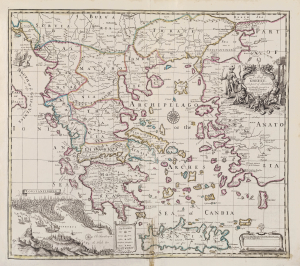
A Map of Greece with part of Anatolia most humbly Inscrib'd to Alexander Uruqhart of Newhall Esq. 1720 Revis'd by J. Senex.
sold
- Digital Map Information
- Suitable for large format printing
- File Size: 2455.27 MB
- File Type: ZIP / TIFF
- ICC color profile embedded
- Delivered instantly via download link
This elegant English map of Greece, produced by John Senex in 1721, presented a British audience with a view of Greece specifically as a possession of the Ottoman Empire. Its beautifully engraved cartouche and its bird's-eye view of Constantinople emphasized the idea that the land presented in the map was one forcibly occupied by the Muslim world in the person of the Ottoman Turks. (more details)
Charting North America's Atlantic Coast.
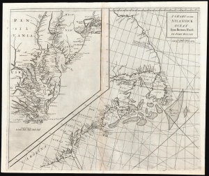
A Chart of the Atlantick Ocean from Buttons Island to Port Royall.
sold
- Digital Map Information
- Suitable for large format printing
- DPI: 600
- File Size: 54.71 MB
- File Type: ZIP / TIFF
- ICC color profile embedded
- Delivered instantly via download link
This is a scarce, elegant 1728 Senex chart of the east coast of North America, from Port Royal in South Carolina to Button Island in Arctic Canada. It includes an inset chart richly detailing Chesapeake and Delaware Bays, and New York Harbor. (more details)