
Thomas Harrison (sold)

Thomas Harrison (c. 1823 - 1894) was a British surveyor active in the Caribbean and Central America, who most notably served as the first Government Surveyor of Jamaica. He had apprenticed under Edward McGeachy (d. c. 1851), whom he succeeded as Surveyor of the county of Surrey on Jamaica. Harrison built upon the work of McGeachy and fulfilled the latter's dream of conducting a detailed scientific survey of the entire island.
First transcontinental railroad.
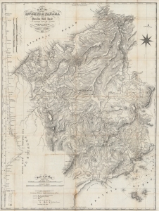
Map of the Isthmus of Panama representing the line of the Panama Rail Road as constructed under the direction of George M. Totten, chief engineer etc.
sold
- Digital Map Information
- Suitable for large format printing
- File Size: 51.16 MB
- File Type: ZIP / TIFF
- ICC color profile embedded
- Delivered instantly via download link
A fascinating 1857 folding map of Panama, highlighting the course of the recently-completed Panama Railroad and the proposed Panama Canal. It was produced by George Totten, the railroad's chief engineer, relying on earlier surveys by Thomas Harrison. (more details)