
Hatano Keisuke (sold) (畠野圭右)

Hatano Keisuke (畠野圭右; 1898 - 19??) was a Japanese illustrator, manga comic artist, and children's book writer active in the middle part of the 20th century. During the Pacific War (December 7, 1941 - September 2, 1945), 1ike most Japanese artists, Hatano's talents were harnessed developing graphic war propaganda. After the war, he continued to product children's cartoon art - or manga - well into the 1960s.
AKA: 畠野圭右
Japanese WWII propaganda - allied ships sunk!
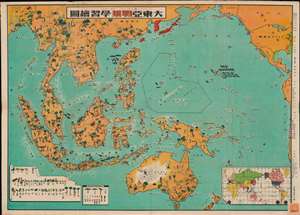
大東亞戦果學習繪圖 / [The Great East Asia Battle Result Learning Map.]
sold
- Digital Map Information
- Suitable for large format printing
- File Size: 36.74 MB
- File Type: ZIP / TIFF
- ICC color profile embedded
- Delivered instantly via download link
A striking 1943 (Showa 18) World War II Japanese Hatano Keisuke (畠野圭右) propaganda map of the Philippines, Southeast Asia, and the East Indies. Roughly centered on the Philippines, coverage extends from the Bay of Bengal to Florida and from Alaska to Tasmania. Sunken Allied ships are illustrated - as are active ships, and Allied air and sea bases. The purposeful distortion of scale serves to underscore the expansiveness of the Japanese Empire and the importance of the East Indian theater to its goals. The cartoonish aspect of the map, the beginnings of Japanese manga tradition, also make clear that it was intended for children. Some early editions of the map feature Japanese flags on captured territories - here they are absent, reflecting how, by 1943, the war had turned against the Imperial Japan and most of its early territorial gains were reversed. (more details)
Japanese WWII propaganda - allied ships sunk!
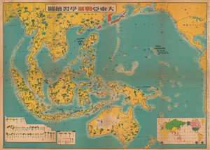
大東亞戦果學習繪圖 / [The Great East Asia Battle Result Learning Map.]
sold
- Digital Map Information
- Suitable for large format printing
- File Size: 34.6 MB
- File Type: ZIP / TIFF
- ICC color profile embedded
- Delivered instantly via download link
This is an uncommon 1944 Hatano Keisuke (畠野圭右) Japanese World War II map propagandizing Japanese victories in the Pacific as well as humorously illustrating resources throughout. Coverage extends from western Sumatra to the Pacific coast of America, and from the Aleutian Islands and Korea to Australia and New Zealand. The map's focus is on the disproportionally enlarged contested Philippine region. The map illustrates ships sunk by Japanese forces, including five in the Philippines and twelve in Hawaii (Pearl Harbor). Red icons highlight Allied naval bases and airstrips. (more details)