
Direccion Hidrografica (sold)

Dirección Hidrografica (1787 - 1927) was the Spanish equivalent of the British Admiralty or the U.S. Coast Survey. This organization, founded in 1787, was commissioned to produce accurate nautical charts of all waters frequented by Spanish vessels. In essence, it replaced the Casa de Contratción, which closed its doors in 1790. Like most such organizations, the Dirección Hidrografica or Depósito Hidrográfico marked a new age in Spanish maritime cartography. Rather than compile charts created by navigators, explorers, and merchants, the Direccion Hidrografica worked closely with naval and military personnel to actually visit the sites directly in pursuit of the most accurate hydrographical, astronomical, and geodetic measurements. The Direccion Hidrografica created a massive library of nautical charts that, though not nearly as common as similar nautical charts by the U.S. Coast Survey and British Admiralty, are highly desirable for the beauty of their manufacture as well as their accuracy and detail. The office was originally located on Calle Ballesta, but relocated to 36 Alcala, both in Madrid. After 1908 the Dirección was subsumed into other governmental agencies. In 1927 the Direccion was absorbed into the Institute and Observatory of San Fernando, located in Cadiz. The library of original maps, charts, and journals was transferred to the Naval Museum of Madrid - where it resides to this day.
Rare Nautical Chart and City Map of Havana and its harbor.
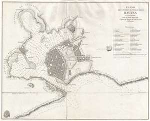
Plano del puerto y ciudad de la Havana levantado por D. José Del Rio Capitan de Fragata de la R. Armada. 1798.
sold
- Digital Map Information
- Suitable for large format printing
- DPI: 300
- File Size: 6.74 MB
- File Type: ZIP / TIFF
- ICC color profile embedded
- Delivered instantly via download link
This is a rare separate issue 1798 Spanish nautical chart and city map of Havana, Cuba, was produced from surveys undertaken by José Del Rio, a captain in the Spanish Royal Navy. The chart covers the city of Havana as well as the harbor. The depiction of the harbor and the coastline is very detailed, offering depth soundings and noting minor variations in the coast. At the upper-right, a list of 37 locations are identified. (more details)
Spain recognizes the Republic of Texas?
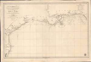
Carta de Las Costas de la Escambia, Alabama y Bocas del rio Misisipi, La Luisiana, tejas, Con la Provincia del Nuevo Santander en el Golfo de Mejico.
sold
- Digital Map Information
- Suitable for large format printing
- DPI: 600
- File Size: 1349.98 MB
- File Type: ZIP / TIFF
- ICC color profile embedded
- Delivered instantly via download link
An unusual 1846 Spanish Direccion Hidrografía nautical chart of the Gulf of Mexico recognizing the Republic of Texas. It is one of very few official Spanish publications to name the Republic of Texas, which Spain never formally recognized. The map emerged during a time of strife, both for Texas, which was involved in its own Texan Revolution (1835 - 1836) followed by the Mexican American War (1846 - 1848), but also in Spain, which was devolving into the Second Carlist War (1846 - 1849). Nonetheless, its production points to the complexity of Spanish-Texan relations during the Revolutionary years, when Texas was blockading Mexican trade and the Spanish West Indies in dire need of fresh trading partners. (more details)