
Himely, Sigismond (sold)

Sigismond Himely (June 7, 1801 - 1872) was a Swiss painter, viewmaker, acquaint engraver active in Paris during the middle part of the 19th century. Hinley was born in La Neuveville, Bern, Switzerland, but moved to Paris to study painting with Copley Fielding (1787 - 1855) and Jean-Victor Bertin (1775 - 1842). He exhibited in the Paris Salons between 1824 and 1869. He is known for his work engraving aquatints for English watercolorists and his names is associated with numerous historical views, city bird's-eye panoramas, architectural illustrations, and ethnographic images, among them rare illustrations of Asia, Africa, and the Americas.
Comparative cartography.
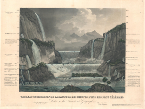
Tableau Comparatif de la Hauteur des Chutes d'Eau Les Plus Célèbres.
sold
- Digital Map Information
- Suitable for large format printing
- Full resolution TIFF file
- ICC color profile embedded
- Delivered instantly via download link
A striking c. 1835 comparative chart illustrating the world's most famous waterfalls. The chart, in the 'Tableau Comparatif' model, sets the world's greatest waterfalls, as understood in the early 19th century, in sharp contrast with one another. (more details)
Infamous island, murky history.
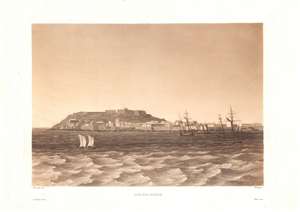
Ile-de-Goree.
sold
- Digital Map Information
- Suitable for large format printing
- DPI: 600
- File Size: 26.04 MB
- File Type: ZIP / TIFF
- ICC color profile embedded
- Delivered instantly via download link
This is a c. 1835 Lauvergne / Himely view of Gorée Island, off the coast of Dakar, Senegal. Various European powers fought over this strategically located island for more than three centuries, during which it became a conduit in the Transatlantic Slave Trade. In the 20th century, the island's Maison des Esclaves became one of the world's most prominent memorials to the slave trade. (more details)
Marvelous separate issue chart with outstanding period guache color!
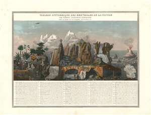
Tableau Pittoresque des Merveilles de la Nature.
sold
- Digital Map Information
- Suitable for large format printing
- DPI: 600
- File Size: 40.11 MB
- File Type: ZIP / TIFF
- ICC color profile embedded
- Delivered instantly via download link
This is a separate issue 1840 Aristide Michel Perrot and Sigismond Himely comparative chart illustrating the marvels of the nature - as they were understood in the 19th century. The present example is notable for its striking gouache color masterfully applied. The chart illustrates 58 numerically identified natural wonders, among them,
- No. 5 - the deep and picturesque Mines of Persberg, Sweden
- No. 8 - a gigantic antediluvian human skeleton fossilized.
- No. 9 - the skeleton of a wooly mammoth.
- no. 30 - the bizarre illusion of giant human beings on the side of a mountain
- no. 29 - Iceland's Mount Hekla volcano.
- No. 18 - the clifftop Corsican city of Bonifacio
- No. 12 - St. Michael's Cave in Gibraltar