
Hung Fat Printing Company (sold) (鴻發印務)

Hung Fat Printing Company (鴻發印務; fl. c. 1930 - 1940), properly Hongfa, was a Chinese owned and operated printing concern based in Hong Kong at 19 Luard Road during the years prior to World War II (1939 - 1945).
AKA: 鴻發印務
An island in a sea of war.
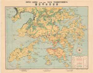
Hong Kong and the New Territories. 香港及新界全圖
sold
- Digital Map Information
- Suitable for large format printing
- File Size: 27.55 MB
- File Type: ZIP / TIFF
- ICC color profile embedded
- Delivered instantly via download link
A scarce and well executed bi-lingual map of Hong Kong and the New Territories issued in 1939, or Minguo 28. Centered on Kowloon and Hong Kong Island, coverage extends from the border with mainland China and Tai Chan Wan, south to include all of Lan Tao and Lamma. The cartographer, Kong San (江山), has introduced a sophisticated coding system to illustrate population density, railways, boundaries, motor and military roads, topography, and more. While most text is in English, Chinese content at bottom center advertises a real-estate firm. (more details)