
Hunting Geology and Geophysics

Hunting Geology and Geophysics Ltd. (1952 - 1987) was a British surveying firm that specialized in cutting-edge methods of mapping, especially aeromagnetic surveys, and focused on discovering potential reserves of natural resources, especially fossil fuels. It was part of the larger Hunting Group, originally founded in 1874 as a shipping company by Charles Hunting, and later moving into aircraft, surveying, and petroleum. Companies within the Hunting group frequently merged with each other and with outside acquisitions, leading to frequent name changes; in this case, Hunting Aerosurveys (founded 1944) merged with Hunting Geophysics (founded 1952) to form Hunting Surveys in 1960. In 1965, a public company was formed called Hunting Associated Industries Ltd., which included Hunting Surveys (Holdings) Ltd. but not a new entity, Hunting Geology and Geophysics Ltd., which remained part of the privately-owned Hunting Group. In 1987, Hunting Geology and Geophysics Ltd. was closed down in a consolidation process that saw the public company (now Hunting PLC) buy out the Hunting Group, though the Hunting family retains a significant share of the company's stock and one of its members remains Chairman of the Board. Hunting Geophysics, and later Hunting Geology and Geophysics Ltd., made pioneering surveys of Great Britain itself, along with several countries in Central Africa (seeking uranium and other minerals), the Philippines, Ethiopia, and especially countries in the Middle East, where the company conducted critically important surveys that helped to develop the lucrative oil industries of the United Arab Emirates, Qatar, and Kuwait, among others.
Early Photogrammetric Aerial Survey of Qatar.
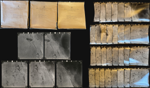
An exceptional discovery: three 1958 portfolios containing 80 original photogrammetric photographs, encompassing three aerial 'runs' over Qatar by Hunting Aerosurveys. They were produced on behalf of J.D. and D.M. Watson, British consulting engineers contracted by Qatar to engineer a stable, clean water supply for the rapidly expanding Doha. Coverage focuses on a peninsula-wide strip just north of Doha commiserate with the site of the ongoing Lusail megadevelopment. (more details)
Birth of Qatar's Petroleum Boom, Prepared on the Eve of Independence.
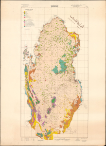
This is a stunning, large-format 1970 bilingual geological map of Qatar, prepared by an international team of geologists and published by Ali Mohammed Jaidah. It represents the first comprehensive geological survey of the country and therefore played an important role in the subsequent development of Qatar's oil and gas industry. (more details)
Seminal Map heralding the birth of Qatar's Petroleum Industry.
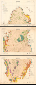
This is a remarkable, very large-format 1970 bilingual three-sheet geological map of Qatar, prepared by an international team of geologists and published by Ali Mohammed Jaidah. It represents the first comprehensive geological survey of the country and therefore played an important role in the subsequent development of Qatar's oil and gas industry. (more details)
Earliest Geological Map of the UAE - the underpinning of regional oil development.
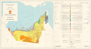
خارطة جيولوجية للإمارات العربية المتحدة / Geological Map of the United Arab Emirates.
$16,000.00
Acquire
This is a scarce, large-format bilingual 1976 geological map of the United Arab Emirates prepared by Hunting Geology and Geophysics Ltd. Produced just after the country's independence and formation, it represents the earliest geological map of the UAE and a benchmark on the country's exploitation of petroleum, which has fueled its phenomenal economic growth in the decades since. (more details)
Maturation of Qatar's Oil and Gas Industries.
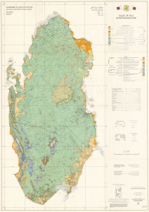
This is an extremely rare 1980 large-format bilingual geological map of Qatar, produced by Hunting Geology and Geophysics for the Qatari government. Issued nearly a decade after independence, the map played an important role in the country's continued development of its oil and gas industries, the wealth from which was successfully leveraged to support wider social and economic development. (more details)
Kuwait Becomes a Major Player in the Global Oil Industry.
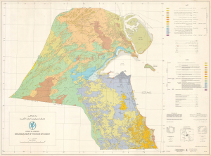
This is a scarce, large-format bilingual geological map of Kuwait, prepared in 1981 by Hunting Geology and Geophysics for the Kuwait Oil Company. It was produced at a time when Kuwait's oil production was undergoing rapid changes, including the creation of the Kuwait Petroleum Corporation (KPC), of which the Kuwait Oil Company became a subsidiary, and expansion into international markets and the securing of vertical integration. (more details)