
1970 Jaidah Bilingual Geological and Petroleum Map of Qatar

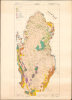
Qatar Geological Map / خريطة قطر الجيولوجية.
Birth of Qatar's Petroleum Boom, Prepared on the Eve of Independence.
Birth of Qatar's Petroleum Boom, Prepared on the Eve of Independence.
This is a stunning, large-format 1970 bilingual geological map of Qatar, prepared by an international team of geologists and published by Ali Mohammed Jaidah. It represents the first comprehensive geological survey of the country and therefore played an important role in the subsequent development of Qatar's oil and gas industry.A Closer Look
The map covers the Qatari Peninsula, using color-shading to indicate a variety of sands, gravels, clay, and stone, as explained in the bilingual legend at top-left. Geologic contacts, anticline axes, the location of fossils, and quarries are also noted. Settlements and geologic features are labeled throughout in English and Arabic, while roads, tracks, oil wells, pipelines, waterways, cultivated areas, sabkhas (coastal mud and salt flats), and other features are recorded, as explained in a legend at the bottom-left. A local grid surrounds the map, described at bottom.Qatar's Oil Industry Takes Off
The early history of Qatar's oil industry began in the 1920s and 1930s, when the small, sparsely populated British protectorate first attracted the interest of international oil companies exploring the Persian Gulf. In 1932, the Anglo-Persian Oil Company obtained the first oil concession in Qatar through a subsidiary, the Iraq Petroleum Company. Initial exploration efforts included geological surveys and test drilling, reflecting British hopes that Qatar might yield oil reserves comparable to those already found in neighboring Bahrain and Saudi Arabia. The first promising discovery came in 1939 at the Dukhan field on Qatar's western coast. However, development was delayed by the outbreak of the Second World War, which diverted resources and prevented large-scale extraction.Oil production in Qatar truly began after the war. In 1947 - 1948, the Dukhan field was finally brought into production, with the first export shipment departing in December 1949. Revenues from oil began to replace traditional industries like pearling, fishing, and small-scale trade. Through the 1950s, the Qatar Petroleum Company (then an operating arm of the concession-holding consortium) expanded infrastructure at Dukhan and the growing port of Umm Said (Mesaieed), which became the center of refining and export operations.
The influx of oil revenue initiated an era of modernization. Beginning in the 1950s, the ruling al-Thani family used oil income to fund public works, schools, healthcare, and roads, gradually transforming Qatar from a relatively poor Gulf sheikhdom into a state with rapidly improving infrastructure and services.
This map was produced on the eve of independence, when Qatar's oil industry entered a period of rapid growth. The discovery and development of new offshore reserves were especially significant during this period, as they expanded Qatar's resource base beyond the aging Dukhan onshore field. One of the most important offshore discoveries was the Bul Hanine field, located southeast of the Qatari peninsula. Discovered in 1970 and brought into production in 1972, Bul Hanine became a key contributor to Qatar's output during the 1970s, reflecting the country's shift toward offshore exploration that would later define much of its energy sector.
Although foreign companies still controlled production at this time, Qatar steadily increased its role in managing the sector, especially after independence. In the early 1970s, the government negotiated increased participation in concessionary operations, aligning with a broader regional trend across the Gulf and the wider Arab world. In 1974, Qatar achieved a majority state share in the Qatar Petroleum Company's operations, reflecting the global momentum of resource nationalization. Oil exports from fields such as Bul Hanine strengthened the young state's financial position, enabling even further investments in education, housing, infrastructure, and early industrialization projects. This era also set the stage for the eventual development of Qatar's massive natural gas resources (especially the North Field, the largest natural gas field in the world), which would propel the country into a new phase of energy leadership in the decades to come.
Publication History and Census
This map was prepared by a combined French-Qatari team of geologists led by Ali Mohammed Jaidah, Deputy Director of the Petroleum Affairs Department (forerunner to the state-owned Qatar General Petroleum Corporation, itself the forerunner to today's QatarEnergy). The geological team was headed by Claude Cavelier, who, along with his colleagues from the Bureau de Recherches Geologiques et Minieres (BRGM) and Qatari geologists (especially Abdullah Salatt), undertook surveys in 1969 - 1970, supplemented by earlier aerial photography by the British firm Hunting Surveys, also active in the region and specializing in producing geological maps to search for potential oil deposits. The result was the first color, comprehensive, stratigraphic geological surveys of Qatar, which laid a foundation for all subsequent geological surveys of the country.There are two printings of the present map, originally two addenda to the geological team's report ('Geological Description of the Qatar Peninsula'), the present single-sheet map on a scale of 1:200,000, and a three-sheet set (also offered by us) on a scale of 1:100,000. Both are quite scarce, with the present single-sheet map only noted among the holdings of the Library of Congress and the Sorbonne Université in the OCLC.
Cartographers
Ali Mohammed Jaidah (September 1941 - present; علي محمد الجيدة), also Latinized as Ali al-Jaidah, Ali Jaïdah, Ali Jida, and Ali Al-Jeeda, is a Qatari oil executive and diplomat who served as the Director General of the Qatar General Petroleum Corporation, the predecessor to today's QatarEnergy, during a period when the country's oil production boomed in the early-mid 1970s. He was born in Doha, Qatar in 1941 to a prominent family of merchants and attended university in Britain, earning a bachelor's and master's degree at the University of London in 1965 and 1966, respectively. He then worked in the Petroleum Affairs Department of the Ministry of Financial and Petroleum in Qatar, quickly becoming the director of the department. In 1976, he represented Qatar at the Organisation of Arab Petroleum Exporting Countries and then became the organization's Secretary General in 1977 - 1978. Afterwards, with Qatar having largely nationalized the oil industry in the meantime, Jaidah returned public service as the managing director of Qatar Petroleum (Qatar General Petroleum Corporation, now QatarEnergy), a post he held until 1985. Jaidah worked in the private sector between 1986 and 1992, after which he was named the Qatari Ambassador to the United Kingdom, a post he held until 2000. He also operated the Jaidah Motors and Trading Company and other family businesses in Doha with his brother Kassem (also as Jassim) which were consolidated into J and A Jaidah Holdings in the early 2000s. Further Details...
Claude Cavelier (June 14, 1935 - present) is a French geologist who undertook important surveys of Qatar, Syria, Oman, and Saudi Arabia. He was born in Colombes near Paris and attended the Lycée Pasteur at Neuilly-sur-Seine and then the Université Catholique de Paris. He received his diploma in geology in 1962 and began working for the Bureau de Recherches Geologiques et Minieres (BRGM). While working for the bureau, he also gradually worked on earning a doctorate, which was awarded in 1976. Beginning as a technician at BRGM, he eventually worked his way up to the position of Geological Director by the end of his career. Much of Cavelier's work was done in the Middle East, at a time when oil exploration and exploitation was expanding rapidly. His geological research therefore had very serious economic and national importance for the countries of the region. In 1969 - 1970, he led a team of geologists on the first comprehensive geological survey of Qatar, work that required difficult forays into the desert with the assistance of Bedouin guides. After this important work in Qatar, Cavelier became the Head of the Geological Mapping and Geology Department at the BRGM and traveled to Syria to train geologists there in methods for large-format surveying. He was again promoted, to Geological Director of the BRGM, in the early 1980s and undertook additional geological surveying in Saudi Arabia and Oman. Cavelier's career also took him to other regions, such as the Antilles and Patagonia, but his most influential and groundbreaking work was in the Middle East and particularly in Qatar. Further Details...
Abdullah Huseein Salatt (عبدالله حسين الصلات; c. 1944 - present) is a Qatari geologist who played an important role in the earliest comprehensive geological surveys of his home country. Salatt was born raised in Doha and distinguished himself as a student, earning a scholarship from the Qatari government to study Petroleum Engineering in the United States, at Texas A and M University. Salatt however gravitated to geology and eventually transferred schools, completing his degree at Lamar State College of Technology. Returning to Qatar, Salatt became the first Qatari citizen with a degree in geology working for the government, in the Department of Petroleum Affairs in the Ministry of Finance and Petroleum. Salatt became an important figure in a joint French-Qatari survey that constituted the first comprehensive geological survey of the country. Having distinguished himself in this important project, Salatt continued served in important roles in the government and oil industry, including Head of the Department of Petroleum Affairs, a member of the Board of the state-owned petroleum company that gradually gained control of domestic production (forerunner to today's QatarEnergy), and Under-Secretary at the Ministry of Communication and Transportation. Further Details...
Hunting Geology and Geophysics Ltd. (1952 - 1987) was a British surveying firm that specialized in cutting-edge methods of mapping, especially aeromagnetic surveys, and focused on discovering potential reserves of natural resources, especially fossil fuels. It was part of the larger Hunting Group, originally founded in 1874 as a shipping company by Charles Hunting, and later moving into aircraft, surveying, and petroleum. Companies within the Hunting group frequently merged with each other and with outside acquisitions, leading to frequent name changes; in this case, Hunting Aerosurveys (founded 1944) merged with Hunting Geophysics (founded 1952) to form Hunting Surveys in 1960. In 1965, a public company was formed called Hunting Associated Industries Ltd., which included Hunting Surveys (Holdings) Ltd. but not a new entity, Hunting Geology and Geophysics Ltd., which remained part of the privately-owned Hunting Group. In 1987, Hunting Geology and Geophysics Ltd. was closed down in a consolidation process that saw the public company (now Hunting PLC) buy out the Hunting Group, though the Hunting family retains a significant share of the company's stock and one of its members remains Chairman of the Board. Hunting Geophysics, and later Hunting Geology and Geophysics Ltd., made pioneering surveys of Great Britain itself, along with several countries in Central Africa (seeking uranium and other minerals), the Philippines, Ethiopia, and especially countries in the Middle East, where the company conducted critically important surveys that helped to develop the lucrative oil industries of the United Arab Emirates, Qatar, and Kuwait, among others. Further Details...
Condition
Very good. A few very minor repaired margin tears. Slight toning.
References
OCLC 495430320. Leblanc, J., A historical account of the stratigraphy of Qatar, Middle East 1816 to 2015, (online publication, 2015), pp. 107-110.