
Hutchins, Thomas (sold)

Thomas Hutchins (1730 – April 18, 1789) was an American military engineer, surveyor, and cartographer active in the second half of the 18th century. Hutchins was born in Monmouth County, New Jersey and joined the British Army as an ensign at 16. He fought with distinction in the French and Indian War. In 1766 Hutchins began working as a military engineer on a Ohio River survey expedition. He later completed additional river surveys throughout the Midwest and in the Florida Panhandle. Hutchins was rumored to have been involved in several land schemes in the lands acquired from France by the 1763 Treaty of Paris, but there is no tangible evidence of such. When the American Revolutionary War broke out he found himself sympathizing with the Continental cause and defected, the only Regular British Officer to do so. After the war, he was appointed 'Geographer of the United States,' the first and only person to have ever held this post. The completed several important surveys in Ohio and laid down the groundwork for the plat system, by which the American west would eventually be parceled according to a regular grid structure and sold. Hutchins influence on the geography of American is therefore staggering, evident in the country structure of most American lands west of the Ohio River, and easily visible from the air. Hutchins died on assignment while surveying the Seven Ranges, Ohio, the first map to follow the Ordinance of 1785. He is interred at the cemetery of the First Presbyterian Church of Pittsburgh.
Very few printed pieces are of more importance in the history of Ohio than this survey of a part of the future state. – 'Fifty Ohio Rarities,' Clements Library.
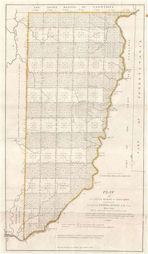
Plat of The Seven Ranges of Townships being Part of the Territory of the United States N.W. of the River Ohio Which by a late act of Congress are directed to be sold.
sold
- Digital Map Information
- Suitable for large format printing
- DPI: 300
- File Size: 6.19 MB
- File Type: ZIP / TIFF
- ICC color profile embedded
- Delivered instantly via download link
This is considered by some to be the map that began the opening of the American west and established the groundwork for the American westward expansion. It was initially published on September 30 of 1786 and is the first map published under the Land Ordinance of ... (more details)