
Imprimerie Lesigne (sold) (Théodore Lesigne)
Imprimerie Lesigne (c. 1843 - 1965) was a Belgian printing firm founded in the mid-19th century (c. 1843) by Théodore Lesigne. By 1856, the firm had established its primary printing works at Nos. 25-27, Rue de la Charité, in the Brussels municipality of Saint-Josse-ten-Noode. Operating over generations under various names, including Imprimerie Th. Lesigne, Veuve Lesigne, and Imprimerie A. Lesigne, the firm became one of Belgium's leading institutional and administrative printing houses. It built a prolific portfolio heavily focused on state and academic commissions, printing official parliamentary reports and debate transcripts, the national statistical yearbook (Annuaire statistique de la Belgique), university annals, and key socio-economic government inquiries. Imprimerie Lesigne continued operations into the 1960s. The firm's historic neoclassical complex on Rue de la Charité was demolished in 1995 as the surrounding district made way for contemporary office development.
AKA: Théodore Lesigne
Coffee, Cotton, and Mines.
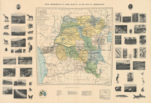
Carte administrative du Congo belge et de ses voies de communication.
sold
- Digital Map Information
- Suitable for large format printing
- Full resolution TIFF file
- ICC color profile embedded
- Delivered instantly via download link
This Jules Flamme 1930 illustrated wall map of the Belgian Congo combines administrative and transport geography with a photographic survey of colonial production. Mines, processing works, and plantation agriculture occupy the margins alongside wildlife and botanical specimens, presenting the territory as both a natural treasury and an industrial enterprise. Its royal portraits give this economic geography a dynastic framework. Published in the year of Belgium's centenary, the map belongs to a period when public celebration of the colonial undertaking increasingly rehabilitated Leopold II as its founding figure. (more details)