
Inoue Mohei (sold) (井上茂兵衛)

Inoue Mohei (井上茂兵衛; 1852 - 1927) was a Japanese cartographer and publisher active in the Meiji period. At the end of the nineteenth century, he served as the head of the Tokyo Jihon Engraving Sales Association (東京地本彫画営業組合), a descendent of the publishers' guilds (地本問屋) that produced ukiyo-e, popular literature, and other essential cultural production of the Tokugawa era. Inoue generally produced nishiki-e (錦絵), an elaborated form of ukiyo-e that were very popular during the Meiji period and which often depicted the introduction or influence of foreign technology, fashion, and ideas in Japan.
AKA: 井上茂兵衛
Japan at the Start of the Meiji Era.
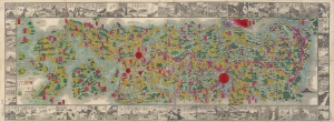
大日本新撰道中全圖 / [New and Complete Traveling Map of Japan].
sold
- Digital Map Information
- Suitable for large format printing
- File Size: 38.84 MB
- File Type: ZIP / TIFF
- ICC color profile embedded
- Delivered instantly via download link
A splendid map of Japan by Inoue Mohei, dated to 1884 but very likely based on an earlier, c. 1870 map. It covers Japan and highlights the country's impressive highway network. More abstractly, it provides an important example of conceptions of Japanese identity at the start of the consequential Meiji Era (1868 - 1912), when the country underwent dramatic changes. (more details)
The height of Meiji era cartography.
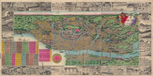
東京方角一覽地圖 / [Tokyo Metropolitan Directions Map].
sold
- Digital Map Information
- Suitable for large format printing
- File Size: 32.22 MB
- File Type: ZIP / TIFF
- ICC color profile embedded
- Delivered instantly via download link
This is a stunning 1880 Meiji 13 Inoue Mohei (井上茂兵衛) bird's-eye view and map of Tokyo, Japan, featuring illustrations of famous sites (bridges, temples, parks, government offices). It is oriented to the west, with Mt. Fuji in the distance and the Imperial Palace (皇居) roughly at center. (more details)